
Magnitude |
2.9 |
| Date & Time (UTC) | 2014-10-12 17:31:42.1 |
| Date & Time (Local) | 1393/7/20 21:01:42.1 |
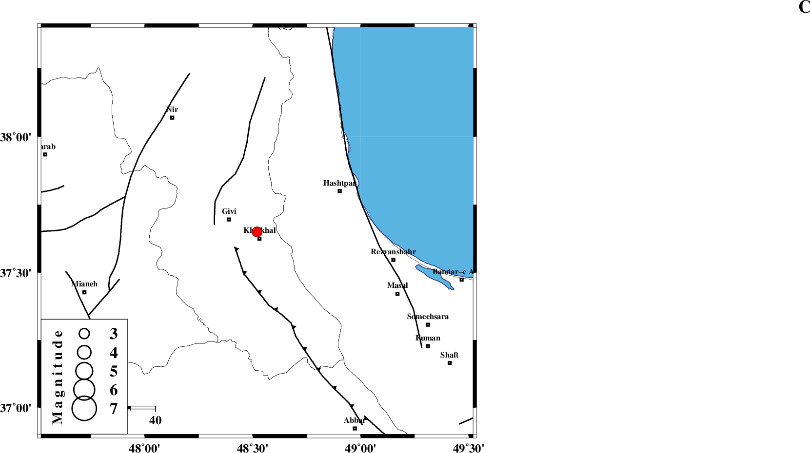
| Location | Lat:37.65 Lon: 48.52 |
| Region | Ardebil Province, 3 km Khalkhal |
Nearest Cities |
|
| 3 km North of Khalkhal, Ardebil Province | |
| 6 km North of Khojin, Ardebil Province | |
| 12 km East of Givi, Ardebil Province | |
| 15 km North East of Gazaz, Ardebil Province | |
| 23 km East of Ganjgah, Ardebil Province | |
| Depth | 14 km |
| Agency | |
Faults within 150 km: |
|
| MASULEL_F (Length: 90 km) , Distance to epicenter: 11 km | |
| SANGAVAR_F (Length: 61 km) , Distance to epicenter: 18 km | |
| TALESH_F (Length: 258 km) , Distance to epicenter: 44 km | |
| Number of Phases | 7 |
| RMS | 0.1 |
| Number of Stations | 5 |
| Error in Latitude | >3.7 km |
| Error in Longitude | 2.7 km |
| Error in Depth | 4.9 km |
Download waveform in seisan format
to download seisan software Click here
to access information about IIEES stations Click here
Amplitude | ||||||||
| UID | Agency | Station | Component | Amplitude | Period | Arrival Time | Proccessing Time | Signal Clip |
| 93868 | IIEES | THKV | N | 50 | 0.44 | 2014-10-12 17:33:06 | 2014-10-12 08:34:00 | n |
Phase | ||||||||||||
| Agency | Station | Component | Phase Type | Phase Quality | First Motion | Observed Arrival Time | Time Residual | Loc. Flag | Input Weight | Distance | Azimuth | |
| IIEES | ZNJK | Z | Pg | E | 2014-10-12 17:32:00 | -0.12 | y | 110 | 172 | |||
| IIEES | THKV | Z | Pn | E | 2014-10-12 17:32:25 | -0.12 | y | 285 | 132 | |||
| IIEES | THKV | N | Sg | E | 2014-10-12 17:33:02 | 0.02 | y | 285 | 132 | |||
| IIEES | CHTH | Z | Pn | E | 2014-10-12 17:32:27 | 0.22 | y | 303 | 129 | |||
| IIEES | CHTH | N | Sg | E | 2014-10-12 17:33:07 | -0.06 | y | 303 | 129 | |||
| IIEES | SNGE | Z | Pn | E | 2014-10-12 17:32:27 | 0.13 | y | 303 | 201 | |||
| IIEES | MAKU | Z | Pn | E | 2014-10-12 17:32:37 | -0.07 | y | 384 | 301 | |||

 IIEES All Rights Reserved