
Magnitude |
3.3 |
| Date & Time (UTC) | 2014-10-19 03:43:08.4 |
| Date & Time (Local) | 1393/7/27 07:13:08.4 |
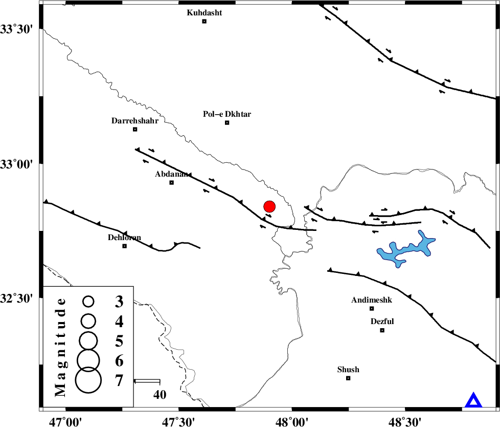
| Location | Lat:32.84 Lon: 47.9 |
| Region | Ilam Province, 39 km South-East of Pol-e dokhtar |
Nearest Cities |
|
| 32 km East of Sarabbagh, Ilam Province | |
| 33 km North West of Bidruyeh, Khoozestan Province | |
| 35 km South East of Sarab hammam, Lorestan Province | |
| 37 km North West of Hoseinieh, Khoozestan Province | |
| 39 km South East of Pol-e dokhtar, Lorestan Province | |
| Depth | 14 km |
| Agency | |
Faults within 150 km: |
|
| BALARUD_F_Z1 (Length: 87 km) , Distance to epicenter: 6 km | |
| BALARUD_F_Z3 (Length: 53 km) , Distance to epicenter: 14 km | |
| MFF6 (Length: 144 km) , Distance to epicenter: 33 km | |
| Number of Phases | 7 |
| RMS | 0.2 |
| Number of Stations | 5 |
| Error in Latitude | >2.2 km |
| Error in Longitude | 5.9 km |
| Error in Depth | 7.7 km |
Download waveform in seisan format
to download seisan software Click here
to access information about IIEES stations Click here
Amplitude | ||||||||
| UID | Agency | Station | Component | Amplitude | Period | Arrival Time | Proccessing Time | Signal Clip |
| 94008 | IIEES | SHGR | N | 676.1 | 0.35 | 2014-10-19 03:43:45 | 2014-10-19 11:25:00 | n |
| 94009 | IIEES | SHGR | E | 628.7 | 0.32 | 2014-10-19 03:43:46 | 2014-10-19 11:25:00 | n |
| 94010 | IIEES | SNGE | N | 174.5 | 0.75 | 2014-10-19 03:44:27 | 2014-10-19 11:25:00 | n |
Phase | ||||||||||||
| Agency | Station | Component | Phase Type | Phase Quality | First Motion | Observed Arrival Time | Time Residual | Loc. Flag | Input Weight | Distance | Azimuth | |
| IIEES | SHGR | Z | Pg | E | 2014-10-19 03:43:28 | 0.23 | y | 117 | 133 | |||
| IIEES | SHGR | E | Sg | E | 2014-10-19 03:43:42 | -0.25 | y | 117 | 133 | |||
| IIEES | KHMZ | Z | Pn | E | 2014-10-19 03:43:43 | -0.11 | y | 217 | 62 | |||
| IIEES | SNGE | Z | Pn | E | 2014-10-19 03:43:47 | -0.28 | y | 255 | 349 | |||
| IIEES | ASAO | Z | Pn | E | 2014-10-19 03:43:50 | 0.3 | y | 274 | 45 | |||
| IIEES | ASAO | N | Sg | E | 2014-10-19 03:44:25 | -0.11 | y | 274 | 45 | |||
| IIEES | GHVR | Z | Pn | E | 2014-10-19 03:44:01 | 0.27 | y | 360 | 59 | |||