
Magnitude |
4 |
| Date & Time (UTC) | 2014-12-05 02:49:29.8 |
| Date & Time (Local) | 1393/9/14 06:19:29.8 |
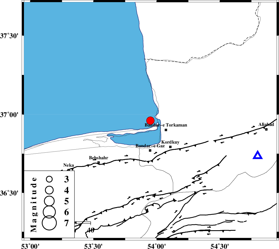
| Location | Lat:36.96 Lon: 53.95 |
| Region | Caspian Sea, 13 km West of Bandar-e torkaman |
Nearest Cities |
|
| 13 km North West of Bandar-e torkaman, Golestan Province | |
| 17 km North West of Sijval, Golestan Province | |
| 19 km South West of Gomishtappeh, Golestan Province | |
| 21 km North of Bandar-e gaz, Golestan Province | |
| 23 km North West of Kordkuy, Golestan Province | |
| Depth | 15 km |
| Agency | |
Faults within 150 km: |
|
| KHAZAR_F (Length: 523 km) , Distance to epicenter: 24 km | |
| N_ALBORZ_F (Length: 360 km) , Distance to epicenter: 51 km | |
| SHAVAR_F (Length: 87 km) , Distance to epicenter: 60 km | |
| Number of Phases | 9 |
| RMS | 0.4 |
| Number of Stations | 9 |
| Error in Latitude | >8.8 km |
| Error in Longitude | 4.5 km |
| Error in Depth | 0 km |
Download waveform in seisan format
to download seisan software Click here
to access information about IIEES stations Click here
Amplitude | ||||||||
| UID | Agency | Station | Component | Amplitude | Period | Arrival Time | Proccessing Time | Signal Clip |
| 94452 | IIEES | THKV | N | 665.2 | 0.44 | 2014-12-05 02:50:52 | 2014-12-05 03:19:00 | n |
| 94453 | IIEES | GHVR | E | 262.1 | 0.32 | 2014-12-05 02:51:13 | 2014-12-05 03:19:00 | n |
| 94454 | IIEES | GHVR | N | 308.4 | 0.56 | 2014-12-05 02:51:16 | 2014-12-05 03:19:00 | n |
Phase | ||||||||||||
| Agency | Station | Component | Phase Type | Phase Quality | First Motion | Observed Arrival Time | Time Residual | Loc. Flag | Input Weight | Distance | Azimuth | |
| IIEES | DAMV | Z | Pn | E | 2014-12-05 02:50:06 | -0.02 | y | 231 | 231 | |||
| IIEES | CHTH | Z | Pn | E | 2014-12-05 02:50:12 | 0.65 | y | 279 | 246 | |||
| IIEES | THKV | Z | Pn | E | 2014-12-05 02:50:14 | -0.6 | y | 299 | 248 | |||
| IIEES | GHVR | Z | Pn | E | 2014-12-05 02:50:23 | 0.02 | y | 368 | 222 | |||
| IIEES | ASAO | Z | Pn | E | 2014-12-05 02:50:32 | -0.16 | y | 444 | 234 | |||
| IIEES | ZNJK | Z | Pn | E | 2014-12-05 02:50:36 | 0.31 | y | 471 | 268 | |||
| IIEES | NASN | Z | Pn | E | 2014-12-05 02:50:36 | -0.25 | y | 473 | 193 | |||
| IIEES | YZKH | Z | Pn | E | 2014-12-05 02:50:41 | 0.21 | y | 510 | 173 | |||
| IIEES | GRMI | Z | Pn | E | 2014-12-05 02:50:48 | -0.22 | y | 571 | 293 | |||