
Magnitude |
3.5 |
| Date & Time (UTC) | 2014-12-25 20:30:24.9 |
| Date & Time (Local) | 1393/10/5 00:00:24.9 |
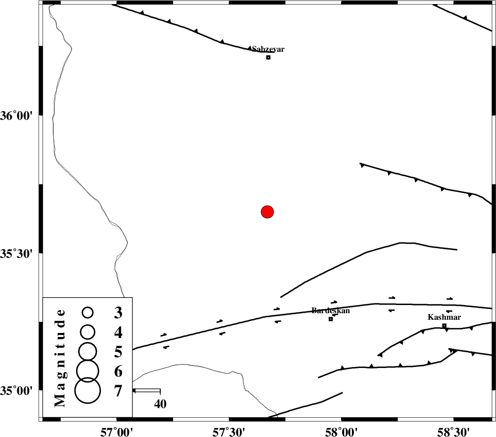
| Location | Lat:35.65 Lon: 57.67 |
| Region | Khorasan(center) Province, 62 km South of Sabzevar |
Nearest Cities |
|
| 17 km South of Bejdan, Khorasan(center) Province | |
| 20 km South West of Tondak, Khorasan(center) Province | |
| 35 km South of Sheshtamad, Khorasan(center) Province | |
| 41 km North West of Kabudan, Khorasan(center) Province | |
| 42 km West of Ghaleh meidan, Khorasan(center) Province | |
| Depth | 17 km |
| Agency | |
Faults within 150 km: |
|
| BIJVARD_F (Length: 83 km) , Distance to epicenter: 32 km | |
| BALHAR_F (Length: 117 km) , Distance to epicenter: 42 km | |
| DORUNEH_F (Length: 713 km) , Distance to epicenter: 42 km | |
| Number of Phases | 7 |
| RMS | 0 |
| Number of Stations | 4 |
| Error in Latitude | >6.1 km |
| Error in Longitude | 2.3 km |
| Error in Depth | 9.1 km |
Download waveform in seisan format
to download seisan software Click here
to access information about IIEES stations Click here
Amplitude | ||||||||
| UID | Agency | Station | Component | Amplitude | Period | Arrival Time | Proccessing Time | Signal Clip |
| 94600 | IIEES | TABS | N | 330.2 | 0.56 | 2014-12-25 20:31:35 | 2014-12-25 09:17:00 | n |
Phase | ||||||||||||
| Agency | Station | Component | Phase Type | Phase Quality | First Motion | Observed Arrival Time | Time Residual | Loc. Flag | Input Weight | Distance | Azimuth | |
| IIEES | TABS | Z | Pn | E | 2014-12-25 20:31:00 | -0.02 | y | 228 | 193 | |||
| IIEES | TABS | N | Sg | E | 2014-12-25 20:31:29 | 0 | y | 228 | 193 | |||
| IIEES | SHRT | Z | Pn | E | 2014-12-25 20:31:12 | 0.02 | y | 327 | 132 | |||
| IIEES | SHRT | N | Sg | E | 2014-12-25 20:31:56 | -0.01 | y | 327 | 132 | |||
| IIEES | BSRN | N | Pn | E | 2014-12-25 20:31:25 | 0 | y | 430 | 161 | |||
| IIEES | BSRN | E | Sg | E | 2014-12-25 20:32:25 | 0.01 | y | 430 | 161 | |||
| IIEES | YZKH | Z | Pn | E | 2014-12-25 20:31:29 | 0.01 | y | 460 | 219 | |||

 IIEES All Rights Reserved