
Magnitude |
4.3 |
| Date & Time (UTC) | 2014-12-30 22:10:19.0 |
| Date & Time (Local) | 1393/10/10 01:40:19.0 |
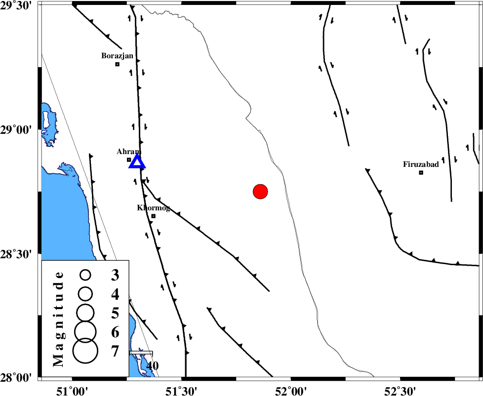
| Location | Lat:28.75 Lon: 51.86 |
| Region | Bushehr Province, 26 km South-West of Farashband |
Nearest Cities |
|
| 26 km South West of Farashband, Fars Province | |
| 27 km South West of Aviz, Fars Province | |
| 41 km North of Shanbeh, Bushehr Province | |
| 42 km South West of Nujin, Fars Province | |
| 45 km South East of Kalameh, Bushehr Province | |
| Depth | 11 km |
| Agency | |
Faults within 150 km: |
|
| MFF5 (Length: 74 km) , Distance to epicenter: 31 km | |
| KAREBASS_F (Length: 98 km) , Distance to epicenter: 44 km | |
| QIR_F (Length: 130 km) , Distance to epicenter: 48 km | |
| Number of Phases | 8 |
| RMS | 0.1 |
| Number of Stations | 7 |
| Error in Latitude | >8.3 km |
| Error in Longitude | 3.9 km |
| Error in Depth | 8.3 km |
Download waveform in seisan format
to download seisan software Click here
to access information about IIEES stations Click here
Amplitude | ||||||||
| UID | Agency | Station | Component | Amplitude | Period | Arrival Time | Proccessing Time | Signal Clip |
| 94645 | IIEES | SHGR | N | 332.9 | 0.48 | 2014-12-30 22:12:18 | 2014-12-30 10:39:00 | n |
| 94646 | IIEES | SHGR | E | 398.7 | 0.6 | 2014-12-30 22:12:59 | 2014-12-30 10:39:00 | n |
Phase | ||||||||||||
| Agency | Station | Component | Phase Type | Phase Quality | First Motion | Observed Arrival Time | Time Residual | Loc. Flag | Input Weight | Distance | Azimuth | |
| IIEES | AHRM | Z | Pg | E | 2014-12-30 22:10:28 | -0.04 | y | 56 | 283 | |||
| IIEES | AHRM | N | Sg | E | 2014-12-30 22:10:36 | 0.03 | y | 56 | 283 | |||
| IIEES | NASN | Z | Pn | E | 2014-12-30 22:11:24 | -0.04 | y | 458 | 11 | |||
| IIEES | SHGR | Z | Pn | E | 2014-12-30 22:11:25 | -0.07 | y | 474 | 322 | |||
| IIEES | YZKH | Z | Pn | E | 2014-12-30 22:11:27 | 0.17 | y | 481 | 32 | |||
| IIEES | KRBR | Z | Pn | E | 2014-12-30 22:11:28 | 0.08 | y | 495 | 73 | |||
| IIEES | ASAO | Z | Pn | E | 2014-12-30 22:11:50 | 0.13 | y | 666 | 345 | |||
| IIEES | TABS | Z | Pn | E | 2014-12-30 22:11:58 | -0.36 | y | 739 | 41 | |||