
Magnitude |
2.2 |
| Date & Time (UTC) | 2015-01-04 20:02:17.1 |
| Date & Time (Local) | 1393/10/14 23:32:17.1 |
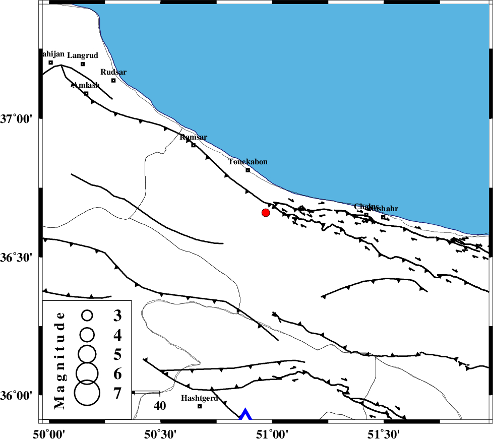
| Location | Lat:36.66 Lon: 50.97 |
| Region | Mazandaran Province, 19 km South of Tonekabon |
Nearest Cities |
|
| 7 km of Kanza, Mazandaran Province | |
| 14 km West of Abbasabad, Mazandaran Province | |
| 16 km South of Khorramabad, Mazandaran Province | |
| 19 km South of Tonekabon, Mazandaran Province | |
| 19 km South East of Soleymanabad, Mazandaran Province | |
| Depth | 14 km |
| Agency | |
Faults within 150 km: |
|
| KHAZAR_F (Length: 523 km) , Distance to epicenter: 4 km | |
| N_ALBORZ_F (Length: 360 km) , Distance to epicenter: 4 km | |
| BONAN_F (Length: 74 km) , Distance to epicenter: 21 km | |
| Number of Phases | 6 |
| RMS | 0.1 |
| Number of Stations | 3 |
| Error in Latitude | >3.7 km |
| Error in Longitude | 4.1 km |
| Error in Depth | 6.8 km |
Download waveform in seisan format
to download seisan software Click here
to access information about IIEES stations Click here
Amplitude | ||||||||
| UID | Agency | Station | Component | Amplitude | Period | Arrival Time | Proccessing Time | Signal Clip |
| 94698 | IIEES | THKV | N | 90.4 | 0.48 | 2015-01-04 20:02:43 | 2015-01-05 04:22:00 | n |
Phase | ||||||||||||
| Agency | Station | Component | Phase Type | Phase Quality | First Motion | Observed Arrival Time | Time Residual | Loc. Flag | Input Weight | Distance | Azimuth | |
| IIEES | THKV | Z | Pg | E | 2015-01-04 20:02:31 | 0.05 | y | 83 | 186 | |||
| IIEES | THKV | N | Sg | E | 2015-01-04 20:02:42 | 0.2 | y | 83 | 186 | |||
| IIEES | CHTH | Z | Pg | E | 2015-01-04 20:02:31 | 0.01 | y | 84.5 | 171 | |||
| IIEES | CHTH | E | Sg | E | 2015-01-04 20:02:42 | -0.24 | y | 84.5 | 171 | |||
| IIEES | ZNJK | Z | Pn | E | 2015-01-04 20:02:50 | 0.07 | y | 204 | 271 | |||
| IIEES | ZNJK | E | Sg | E | 2015-01-04 20:03:15 | -0.09 | y | 204 | 271 | |||