
Magnitude |
3.2 |
| Date & Time (UTC) | 2015-01-05 20:16:11.8 |
| Date & Time (Local) | 1393/10/15 23:46:11.8 |
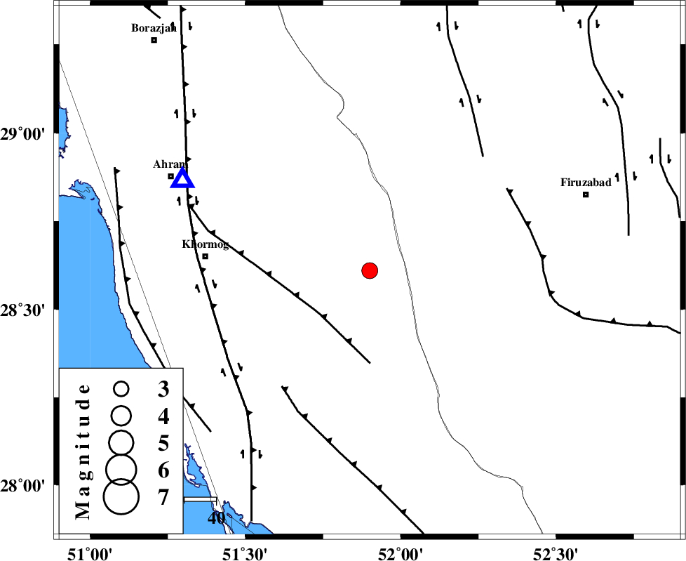
| Location | Lat:28.61 Lon: 51.9 |
| Region | Bushehr Province, 34 km South-West of Farashband |
Nearest Cities |
|
| 28 km North East of Shanbeh, Bushehr Province | |
| 34 km South West of Farashband, Fars Province | |
| 38 km South West of Aviz, Fars Province | |
| 42 km North West of Dahrom, Fars Province | |
| 46 km North East of Baduleh, Bushehr Province | |
| Depth | 18 km |
| Agency | |
Faults within 150 km: |
|
| MFF5 (Length: 74 km) , Distance to epicenter: 21 km | |
| MFF3 (Length: 292 km) , Distance to epicenter: 46 km | |
| QIR_F (Length: 130 km) , Distance to epicenter: 50 km | |
| Number of Phases | 6 |
| RMS | 0.2 |
| Number of Stations | 5 |
| Error in Latitude | >8.5 km |
| Error in Longitude | 1.8 km |
| Error in Depth | 4 km |
Download waveform in seisan format
to download seisan software Click here
to access information about IIEES stations Click here
Amplitude | ||||||||
| UID | Agency | Station | Component | Amplitude | Period | Arrival Time | Proccessing Time | Signal Clip |
| 94706 | IIEES | AHRM | N | 1275.3 | 0.52 | 2015-01-05 20:16:42 | 2015-01-05 08:48:00 | n |
| 94707 | IIEES | ASAO | E | 6.8 | 0.64 | 2015-01-05 20:19:21 | 2015-01-05 08:48:00 | n |
Phase | ||||||||||||
| Agency | Station | Component | Phase Type | Phase Quality | First Motion | Observed Arrival Time | Time Residual | Loc. Flag | Input Weight | Distance | Azimuth | |
| IIEES | AHRM | Z | Pg | E | 2015-01-05 20:16:23 | 0.03 | y | 65.4 | 296 | |||
| IIEES | YZKH | Z | Pn | E | 2015-01-05 20:17:20 | 0.23 | y | 492 | 31 | |||
| IIEES | KRBR | Z | Pn | E | 2015-01-05 20:17:20 | -0.06 | y | 496 | 71 | |||
| IIEES | KRBR | E | Sg | E | 2015-01-05 20:18:30 | -0.05 | y | 496 | 71 | |||
| IIEES | ASAO | Z | Pn | E | 2015-01-05 20:17:43 | -0.3 | y | 682 | 345 | |||
| IIEES | TABS | Z | Pn | E | 2015-01-05 20:17:52 | 0.07 | y | 748 | 40 | |||