
Magnitude |
2.8 |
| Date & Time (UTC) | 2015-02-24 07:33:04.3 |
| Date & Time (Local) | 1393/12/5 11:03:04.3 |
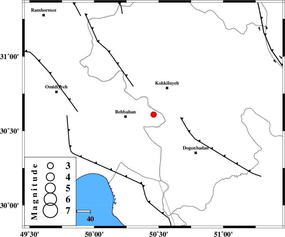
| Location | Lat:30.61 Lon: 50.46 |
| Region | Khoozestan Province, 21 km East of Behbahan |
Nearest Cities |
|
| 16 km East of Mansuriyeh, Khoozestan Province | |
| 21 km North East of Behbahan, Khoozestan Province | |
| 22 km South West of Dehdasht, Kohkiluieh va boyerahmad Province | |
| 29 km South East of Dodange-ye bozorg, Khoozestan Province | |
| 40 km North East of Sardasht, Khoozestan Province | |
| Depth | 14 km |
| Agency | |
Faults within 150 km: |
|
| MISHAN_F (Length: 76 km) , Distance to epicenter: 20 km | |
| MFF4 (Length: 62 km) , Distance to epicenter: 26 km | |
| RAG_E_SEFID_F (Length: 84 km) , Distance to epicenter: 51 km | |
| Number of Phases | 6 |
| RMS | 0.3 |
| Number of Stations | 4 |
| Error in Latitude | >2.3 km |
| Error in Longitude | 6.8 km |
| Error in Depth | 5.5 km |
Download waveform in seisan format
to download seisan software Click here
to access information about IIEES stations Click here
Amplitude | ||||||||
| UID | Agency | Station | Component | Amplitude | Period | Arrival Time | Proccessing Time | Signal Clip |
| 95088 | IIEES | AHRM | N | 72 | 0.58 | 2015-02-24 07:34:17 | 2015-02-24 08:10:00 | n |
| 95089 | IIEES | YZKH | N | 14.7 | 0.37 | 2015-02-24 07:34:57 | 2015-02-24 08:10:00 | n |
| 95090 | IIEES | YZKH | E | 15.9 | 0.27 | 2015-02-24 07:34:57 | 2015-02-24 08:10:00 | n |
Phase | ||||||||||||
| Agency | Station | Component | Phase Type | Phase Quality | First Motion | Observed Arrival Time | Time Residual | Loc. Flag | Input Weight | Distance | Azimuth | |
| IIEES | AHRM | Z | Pg | E | 2015-02-24 07:33:38 | -0.43 | y | 209 | 157 | |||
| IIEES | AHRM | N | S | E | 2015-02-24 07:34:02 | 0.38 | y | 209 | 157 | |||
| IIEES | NASN | Z | Pn | E | 2015-02-24 07:33:53 | 0.08 | y | 329 | 42 | |||
| IIEES | ASAO | Z | Pn | E | 2015-02-24 07:34:06 | 0.11 | y | 439 | 355 | |||
| IIEES | YZKH | Z | Pn | E | 2015-02-24 07:34:06 | -0.06 | y | 439 | 62 | |||
| IIEES | YZKH | E | S | E | 2015-02-24 07:34:52 | -0.08 | y | 439 | 62 | |||