
Magnitude |
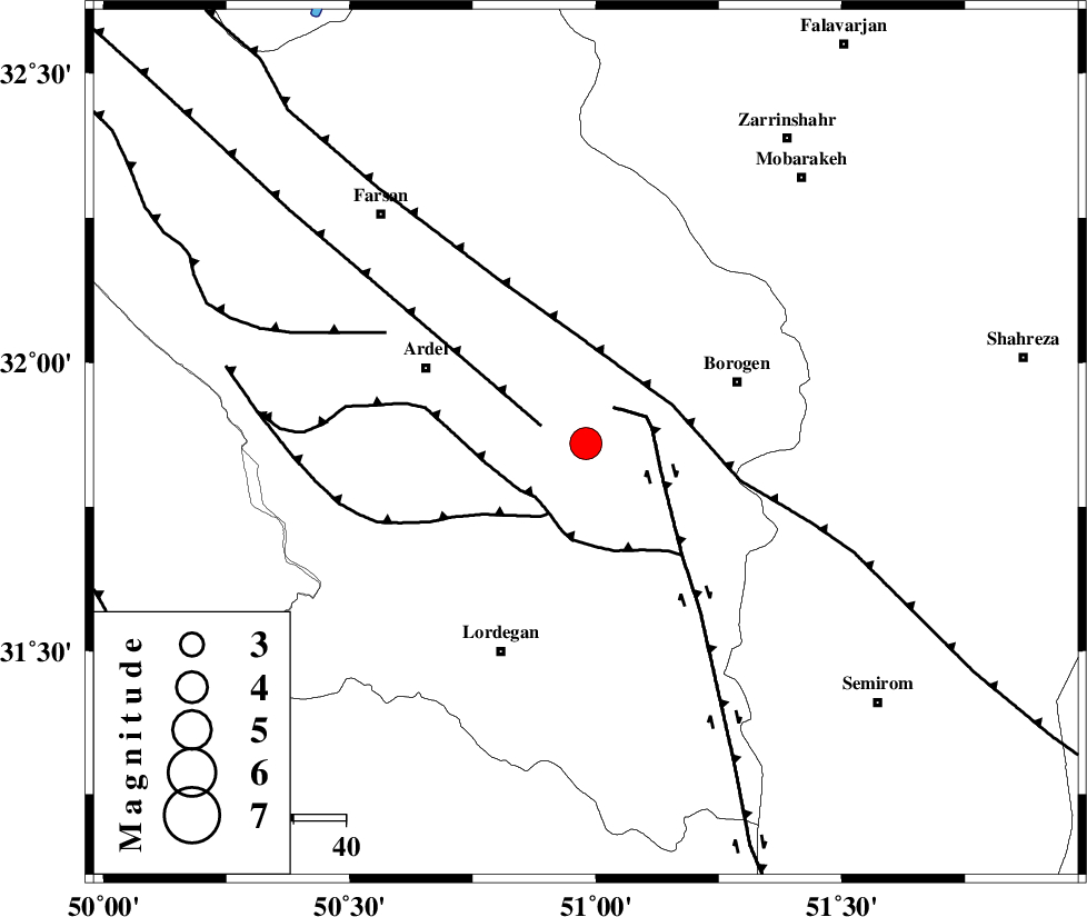
4.1 |
| Date & Time (UTC) | 2015-02-25 08:34:49.1 |
| Date & Time (Local) | 1393/12/6 12:04:49.1 |
| Location | Lat:31.86 Lon: 50.98 |
| Region | Chaharmahal Bakhtiari Province, 32 km South-West of Borujen |
Nearest Cities |
|
| 10 km of Baladaji, Chaharmahal Bakhtiari Province | |
| 17 km West of Gandoman, Chaharmahal Bakhtiari Province | |
| 24 km East of Naghan, Chaharmahal Bakhtiari Province | |
| 25 km South West of Faradonbeh, Chaharmahal Bakhtiari Province | |
| 26 km South East of Shalamzar, Chaharmahal Bakhtiari Province | |
| Depth | 18 km |
| Agency | |
Faults within 150 km: |
|
| DENA_F (Length: 137 km) , Distance to epicenter: 9 km | |
| ARDAL_F (Length: 170 km) , Distance to epicenter: 9 km | |
| DOPOLAN_F (Length: 107 km) , Distance to epicenter: 14 km | |
| Number of Phases | 6 |
| RMS | 0.1 |
| Number of Stations | 4 |
| Error in Latitude | >3.3 km |
| Error in Longitude | 2.6 km |
| Error in Depth | 6.9 km |
Download waveform in seisan format
to download seisan software Click here
to access information about IIEES stations Click here
Amplitude | ||||||||
| UID | Agency | Station | Component | Amplitude | Period | Arrival Time | Proccessing Time | Signal Clip |
| 95095 | IIEES | SHGR | N | 1536.9 | 0.51 | 2015-02-25 08:36:06 | 2015-02-25 09:12:00 | n |
Phase | ||||||||||||
| Agency | Station | Component | Phase Type | Phase Quality | First Motion | Observed Arrival Time | Time Residual | Loc. Flag | Input Weight | Distance | Azimuth | |
| IIEES | NASN | Z | Pn | E | 2015-02-25 08:35:21 | -0.11 | y | 201 | 58 | |||
| IIEES | SHGR | Z | Pn | E | 2015-02-25 08:35:21 | -0.21 | y | 208 | 278 | |||
| IIEES | SHGR | N | Sg | E | 2015-02-25 08:35:48 | 0.13 | y | 208 | 278 | |||
| IIEES | GHVR | Z | Pn | E | 2015-02-25 08:35:32 | 0.02 | y | 292 | 5 | |||
| IIEES | GHVR | N | Sg | E | 2015-02-25 08:36:11 | 0 | y | 292 | 5 | |||
| IIEES | YZKH | Z | Pn | E | 2015-02-25 08:35:39 | 0.19 | y | 346 | 79 | |||