
Magnitude |
2.7 |
| Date & Time (UTC) | 2015-04-18 16:34:11.9 |
| Date & Time (Local) | 1394/1/29 21:04:11.9 |
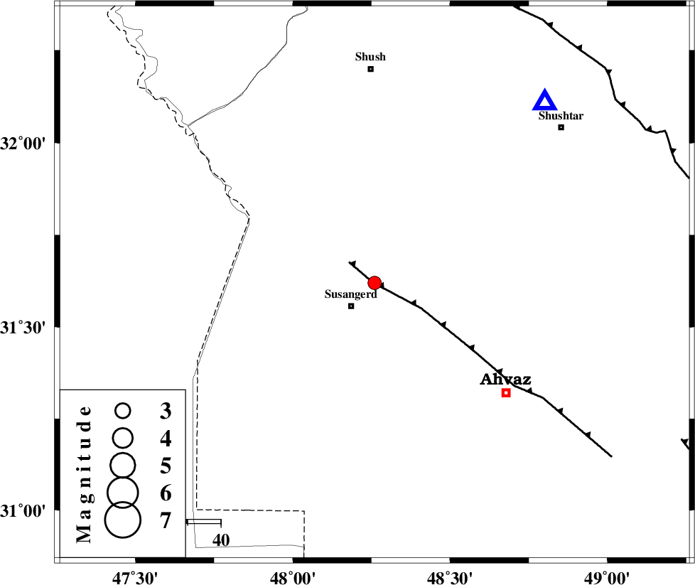
| Location | Lat:31.62 Lon: 48.26 |
| Region | Khoozestan Province, 10 km Susangerd |
Nearest Cities |
|
| 10 km North of Jalaliyeh, Khoozestan Province | |
| 10 km North of Susangerd, Khoozestan Province | |
| 22 km North West of Hamidiyeh, Khoozestan Province | |
| 25 km North East of Hoveizeh, Khoozestan Province | |
| 26 km South West of Abdolkhan-eali, Khoozestan Province | |
| Depth | 14 km |
| Agency | |
Faults within 150 km: |
|
| AHVAZ_F (Length: 99 km) , Distance to epicenter: 0 km | |
| DEZFUL_EMBAYMENT (Length: 228 km) , Distance to epicenter: 91 km | |
| AGHAJARI_F (Length: 88 km) , Distance to epicenter: 104 km | |
| Number of Phases | 5 |
| RMS | 0.1 |
| Number of Stations | 4 |
| Error in Latitude | >4.4 km |
| Error in Longitude | 6.8 km |
| Error in Depth | 6.6 km |
Download waveform in seisan format
to download seisan software Click here
to access information about IIEES stations Click here
Amplitude | ||||||||
| UID | Agency | Station | Component | Amplitude | Period | Arrival Time | Proccessing Time | Signal Clip |
| 95451 | IIEES | SHGR | N | 338.2 | 0.6 | 2015-04-18 16:34:44 | 2015-04-18 04:54:00 | n |
Phase | ||||||||||||
| Agency | Station | Component | Phase Type | Phase Quality | First Motion | Observed Arrival Time | Time Residual | Loc. Flag | Input Weight | Distance | Azimuth | |
| IIEES | SHGR | Z | Pg | E | 2015-04-18 16:34:24 | -0.14 | y | 74.7 | 43 | |||
| IIEES | KHMZ | Z | Pn | E | 2015-04-18 16:34:55 | 0.08 | y | 284 | 34 | |||
| IIEES | ASAO | Z | Pn | E | 2015-04-18 16:35:05 | 0.14 | y | 364 | 26 | |||
| IIEES | ASAO | N | Sg | E | 2015-04-18 16:35:54 | 0.02 | y | 364 | 26 | |||
| IIEES | SNGE | Z | Pn | E | 2015-04-18 16:35:08 | -0.08 | y | 395 | 348 | |||