
Magnitude |
2.2 |
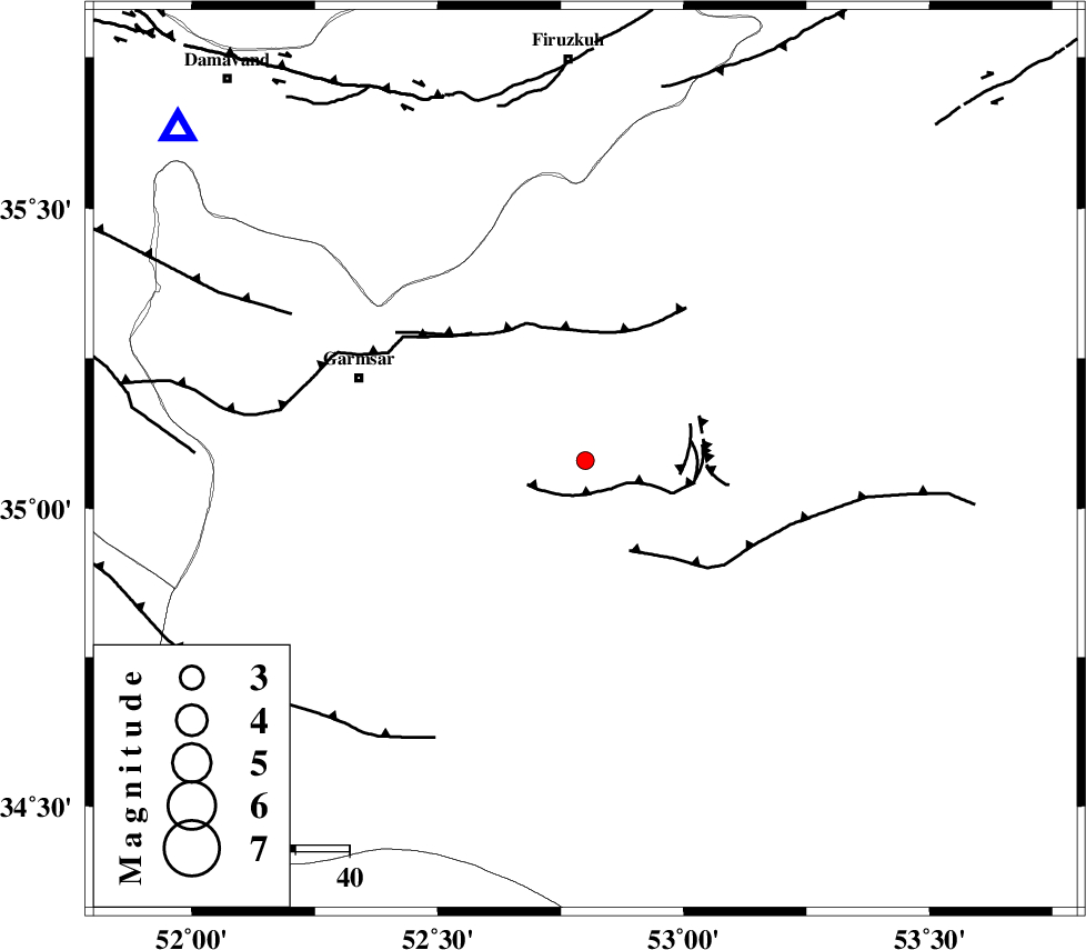
| Date & Time (UTC) | 2015-04-30 18:37:56.4 |
| Date & Time (Local) | 1394/2/10 23:07:56.4 |
| Location | Lat:35.08 Lon: 52.8 |
| Region | Semnan Province, 45 km South-East of Garmsar |
Nearest Cities |
|
| 28 km South East of Kohanabad, Semnan Province | |
| 31 km South East of Aradan, Semnan Province | |
| 34 km South East of Davarabad, Semnan Province | |
| 37 km East of Gardovan, Semnan Province | |
| 45 km South West of Lasjerd, Semnan Province | |
| Depth | 46 km |
| Agency | |
Faults within 150 km: |
|
| KUH_E_GACHAB_F1 (Length: 53 km) , Distance to epicenter: 5 km | |
| KUH_E_GUGERD_F (Length: 73 km) , Distance to epicenter: 19 km | |
| GARMSAR_F (Length: 77 km) , Distance to epicenter: 32 km | |
| Number of Phases | 4 |
| RMS | 0 |
| Number of Stations | 3 |
| Error in Latitude | >3.5 km |
| Error in Longitude | 8.2 km |
| Error in Depth | 14.6 km |
Download waveform in seisan format
to download seisan software Click here
to access information about IIEES stations Click here
Amplitude | ||||||||
| UID | Agency | Station | Component | Amplitude | Period | Arrival Time | Proccessing Time | Signal Clip |
| 95546 | IIEES | GHVR | E | 34.2 | 0.36 | 2015-04-30 18:38:49 | 2015-05-01 03:25:00 | n |
| 95547 | IIEES | GHVR | N | 34.2 | 0.48 | 2015-04-30 18:38:49 | 2015-05-01 03:25:00 | n |
| 95548 | IIEES | CHTH | E | 28.6 | 0.4 | 2015-04-30 18:38:47 | 2015-05-01 03:25:00 | n |
Phase | ||||||||||||
| Agency | Station | Component | Phase Type | Phase Quality | First Motion | Observed Arrival Time | Time Residual | Loc. Flag | Input Weight | Distance | Azimuth | |
| IIEES | DAMV | Z | Pg | E | 2015-04-30 18:38:13 | 0 | y | 97.6 | 309 | |||
| IIEES | GHVR | Z | Pg | E | 2015-04-30 18:38:22 | 0 | y | 157 | 246 | |||
| IIEES | GHVR | N | Sg | E | 2015-04-30 18:38:41 | 0 | y | 157 | 246 | |||
| IIEES | CHTH | Z | Pg | E | 2015-04-30 18:38:25 | 0 | y | 178 | 302 | |||