
Magnitude |
1.6 |
| Date & Time (UTC) | 2015-05-05 05:09:41.5 |
| Date & Time (Local) | 1394/2/15 09:39:41.5 |
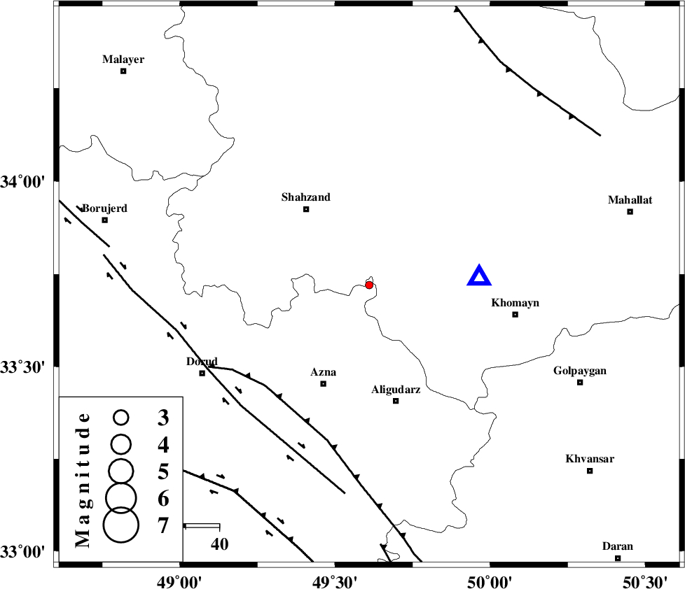
| Location | Lat:33.72 Lon: 49.61 |
| Region | Lorestan Province, 36 km North of Aligudarz |
Nearest Cities |
|
| 17 km South of Hafteh, Markazi Province | |
| 18 km North West of Javadiyeh, Markazi Province | |
| 23 km North West of Qorchibashi, Markazi Province | |
| 23 km South West of Qasemabad, Markazi Province | |
| 23 km South East of Azodiyeh, Markazi Province | |
| Depth | 14 km |
| Agency | |
Faults within 150 km: |
|
| MAIN_ZAGROS_R_F (Length: 1106 km) , Distance to epicenter: 43 km | |
| DORUD (Length: 100 km) , Distance to epicenter: 53 km | |
| HZF4 (Length: 492 km) , Distance to epicenter: 74 km | |
| Number of Phases | 6 |
| RMS | 0.1 |
| Number of Stations | 4 |
| Error in Latitude | >2.2 km |
| Error in Longitude | 3.7 km |
| Error in Depth | 8.1 km |
Download waveform in seisan format
to download seisan software Click here
to access information about IIEES stations Click here
Amplitude | ||||||||
| UID | Agency | Station | Component | Amplitude | Period | Arrival Time | Proccessing Time | Signal Clip |
| 95578 | IIEES | ASAO | N | 20.6 | 0.29 | 2015-05-05 05:10:12 | 2015-05-05 07:33:00 | n |
| 95579 | IIEES | ASAO | E | 19.9 | 0.42 | 2015-05-05 05:10:16 | 2015-05-05 07:33:00 | n |
Phase | ||||||||||||
| Agency | Station | Component | Phase Type | Phase Quality | First Motion | Observed Arrival Time | Time Residual | Loc. Flag | Input Weight | Distance | Azimuth | |
| IIEES | KHMZ | Z | Pg | E | 2015-05-05 05:09:47 | -0.09 | y | 32.9 | 87 | |||
| IIEES | ASAO | Z | Pg | E | 2015-05-05 05:09:58 | 0.18 | y | 99.1 | 23 | |||
| IIEES | ASAO | E | Sg | E | 2015-05-05 05:10:10 | -0.15 | y | 99.1 | 23 | |||
| IIEES | GHVR | Z | Pg | E | 2015-05-05 05:10:09 | -0.07 | y | 173 | 60 | |||
| IIEES | GHVR | E | Sg | E | 2015-05-05 05:10:30 | 0.14 | y | 173 | 60 | |||
| IIEES | SNGE | Z | Pn | E | 2015-05-05 05:10:21 | 0 | y | 258 | 307 | |||