
Magnitude |
2.9 |
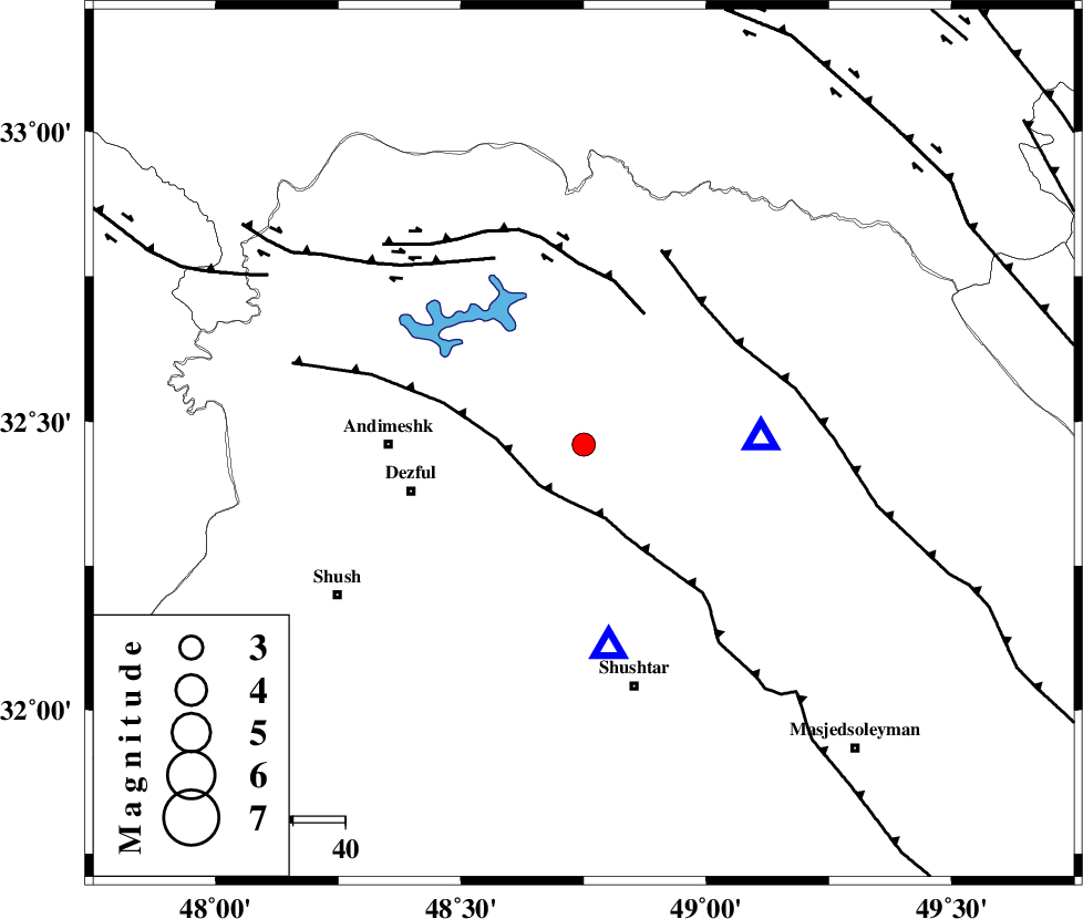
| Date & Time (UTC) | 2015-06-20 01:36:43.3 |
| Date & Time (Local) | 1394/3/30 06:06:43.3 |
| Location | Lat:32.46 Lon: 48.75 |
| Region | Khoozestan Province, 37 km East of Andimeshk |
Nearest Cities |
|
| 9 km of Sardasht, Khoozestan Province | |
| 11 km North of Mahur berenji, Khoozestan Province | |
| 25 km North of Gatvand, Khoozestan Province | |
| 31 km North West of Samaleh, Khoozestan Province | |
| 34 km North East of Dezful, Khoozestan Province | |
| Depth | 31 km |
| Agency | |
Faults within 150 km: |
|
| DEZFUL_EMBAYMENT (Length: 228 km) , Distance to epicenter: 11 km | |
| BALARUD_F_Z2 (Length: 58 km) , Distance to epicenter: 28 km | |
| MFF2 (Length: 205 km) , Distance to epicenter: 35 km | |
| Number of Phases | 7 |
| RMS | 0.2 |
| Number of Stations | 5 |
| Error in Latitude | >3 km |
| Error in Longitude | 7.7 km |
| Error in Depth | 3 km |
Download waveform in seisan format
to download seisan software Click here
to access information about IIEES stations Click here
Amplitude | ||||||||
| UID | Agency | Station | Component | Amplitude | Period | Arrival Time | Proccessing Time | Signal Clip |
| 95986 | IIEES | GHVR | N | 36.6 | 0.6 | 2015-06-20 01:38:10 | 2015-06-20 02:58:00 | n |
Phase | ||||||||||||
| Agency | Station | Component | Phase Type | Phase Quality | First Motion | Observed Arrival Time | Time Residual | Loc. Flag | Input Weight | Distance | Azimuth | |
| IIEES | SHGR | Z | Pg | E | 2015-06-20 01:36:51 | -0.31 | y | 39.4 | 173 | |||
| IIEES | SHGR | N | Sg | E | 2015-06-20 01:36:57 | 0.24 | y | 39.4 | 173 | |||
| IIEES | KHMZ | Z | Pn | E | 2015-06-20 01:37:12 | -0.02 | y | 182 | 38 | |||
| IIEES | KHMZ | Z | Sg | E | 2015-06-20 01:37:34 | -0.02 | y | 182 | 38 | |||
| IIEES | ASAO | Z | Pn | E | 2015-06-20 01:37:22 | 0.15 | y | 260 | 27 | |||
| IIEES | GHVR | Z | Pn | E | 2015-06-20 01:37:29 | 0.04 | y | 323 | 45 | |||
| IIEES | NASN | Z | Pn | E | 2015-06-20 01:37:37 | -0.09 | y | 383 | 83 | |||