Home / Recent Earthquakes

| Prel. Rep. | Date | Time(UTC) | Time(Local) | Lat. | Lon. | Depth | Mag. | Region | Waveform |
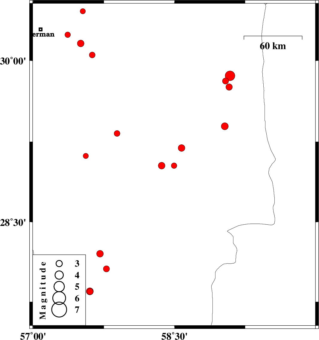
| 2017/06/15 | 01:54:41.1 | 06:24:41.1 | 29.027 | 58.495 | 14 | ML:2.7 | Kerman Province, 16 km -East of Bam | ||
| 2017/06/12 | 12:45:11.7 | 17:15:11.7 | 29.191 | 58.574 | 14 | ML:3.3 | Kerman Province, 23 km -East of Bam | ||
| 2017/06/12 | 10:01:26.5 | 14:31:26.5 | 30.239 | 57.367 | 9 | ML:2.7 | Kerman Province, 28 km -East of Kerman | ||
| 2017/06/10 | 04:34:56.1 | 09:04:56.1 | 29.812 | 59.041 | 14 | ML:2.9 | Kerman Province, 102 km North-East of Bam | ||
| 2017/06/10 | 04:07:03.4 | 08:37:03.4 | 29.86 | 59.089 | 14 | ML:4.7 | Kerman Province, 110 km North-East of Bam | ||
| 2017/06/09 | 22:20:10.8 | 02:50:10.8 | 29.756 | 59.08 | 14 | ML:3.1 | Kerman Province, 100 km North-East of Bam | ||
| 2017/06/06 | 12:46:10.5 | 17:16:10.5 | 30.455 | 57.527 | 17 | ML:2.6 | Kerman Province, 47 km North-East of Kerman | ||
| 2017/06/05 | 15:34:22.0 | 20:04:22.0 | 30.159 | 57.504 | 14 | ML:3.2 | Kerman Province, 43 km South-East of Kerman | ||
| 2017/06/03 | 17:27:03.0 | 21:57:03.0 | 29.393 | 59.033 | 15 | ML:3.4 | Kerman Province, 73 km North-East of Bam | ||
| 2017/06/01 | 11:42:48.6 | 16:12:48.6 | 29.027 | 58.364 | 14 | ML:3.3 | Kerman Province, 9 km of Bam | ||
| 2017/05/31 | 11:51:21.7 | 16:21:21.7 | 29.326 | 57.89 | 7 | ML:2.8 | Kerman Province, 51 km North-West of Bam | ||
| 2017/05/26 | 17:09:03.9 | 21:39:03.9 | 28.061 | 57.777 | 18 | ML:2.9 | Kerman Province, 15 km North of Kahnuj | ||
| 2017/05/26 | 06:33:51.6 | 11:03:51.6 | 28.203 | 57.709 | 14 | ML:3.3 | Kerman Province, 28 km North of Kahnuj | ||
| 2017/05/20 | 16:37:26.7 | 21:07:26.7 | 29.117 | 57.558 | 14 | ML:2.5 | Kerman Province, 53 km North-West of Jiroft | ||
| 2017/05/19 | 05:29:10.7 | 09:59:10.7 | 27.846 | 57.604 | 14 | ML:2.9 | Kerman Province, 15 km South of Kahnuj | ||
| 2017/05/19 | 03:42:31.8 | 08:12:31.8 | 27.849 | 57.602 | 14 | ML:3.4 | Kerman Province, 14 km South of Kahnuj | ||
| 2017/05/17 | 18:04:22.0 | 22:34:22.0 | 30.052 | 57.627 | 18 | ML:2.8 | Kerman Province, 59 km South-East of Kerman |