| Prel. Rep. | Date | Time(UTC) | Time(Local) | Lat. | Lon. | Depth | Mag. | Region | Waveform |
|
|
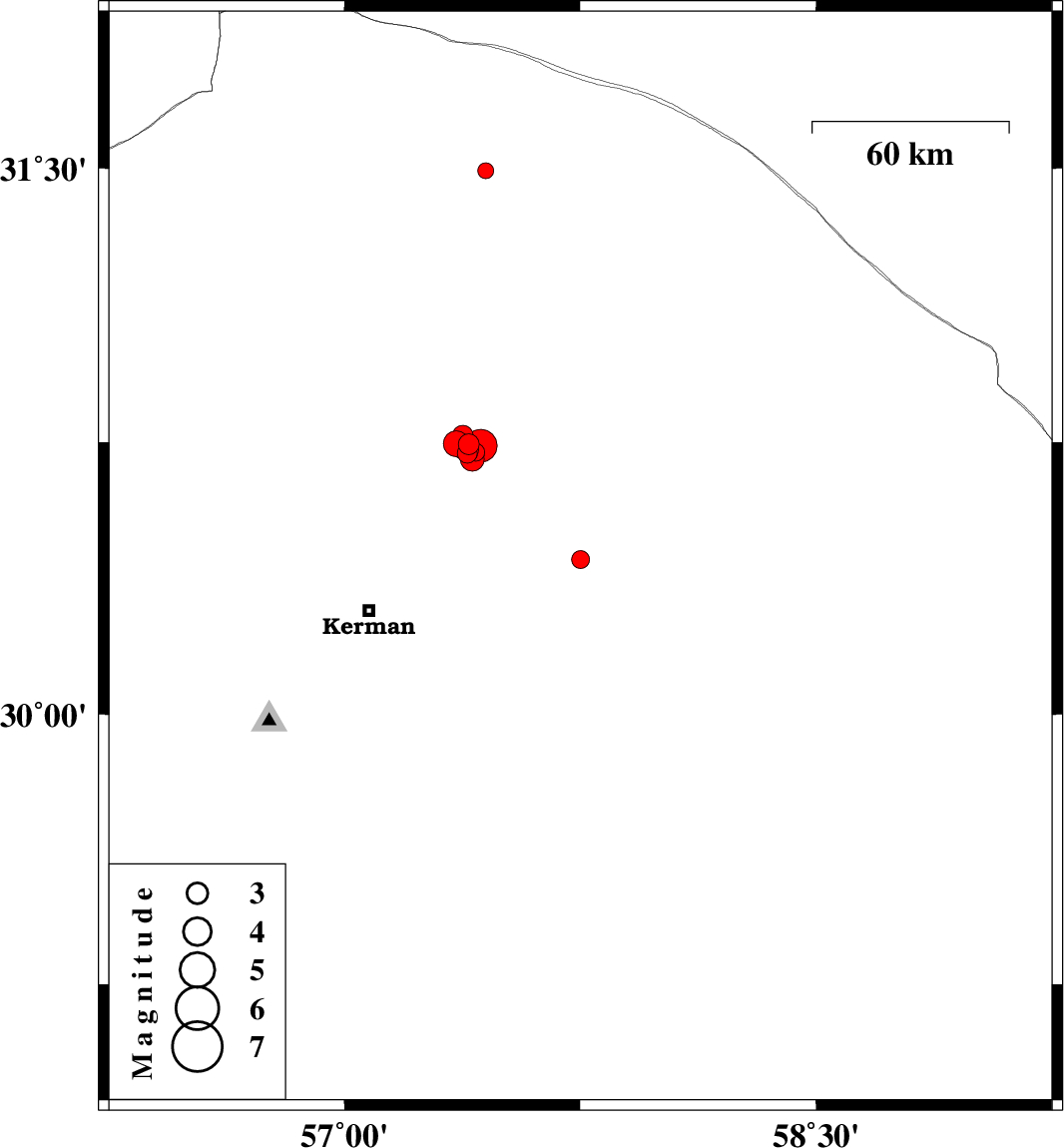
2017/10/21
|
17:52:01.8
|
21:22:01.8
| 30.428 | 57.751 | 14 |
ML:2.5
|
Kerman Province, 66 km North-East of Kerman | |
|
|
2017/10/20
|
13:14:36.4
|
16:44:36.4
| 30.745 | 57.396 | 18 |
ML:3
|
Kerman Province, 59 km North-East of Kerman | |
|
|
2017/10/14
|
03:43:34.3
|
07:13:34.3
| 30.72 | 57.391 | 14 |
ML:2.8
|
Kerman Province, 57 km North-East of Kerman | |
|
|
2017/10/13
|
06:45:54.7
|
10:15:54.7
| 31.493 | 57.449 | 14 |
ML:2.3
|
Kerman Province, 66 km North-East of Ravar | |
|
|
2017/10/11
|
03:58:21.4
|
07:28:21.4
| 30.747 | 57.356 | 14 |
ML:3.6
|
Kerman Province, 58 km North-East of Kerman | |
|
|
2017/10/07
|
01:06:59.8
|
04:36:59.8
| 30.731 | 57.397 | 14 |
ML:2.7
|
Kerman Province, 58 km North-East of Kerman | |
|
|
2017/09/30
|
19:04:22.8
|
22:34:22.8
| 30.722 | 57.395 | 14 |
ML:2.5
|
Kerman Province, 57 km North-East of Kerman | |
|
|
2017/09/24
|
09:02:37.4
|
12:32:37.4
| 30.723 | 57.418 | 14 |
ML:2.5
|
Kerman Province, 58 km North-East of Kerman | |
|
|
2017/09/22
|
23:49:56.3
|
03:19:56.3
| 30.74 | 57.377 | 14 |
ML:3.5
|
Kerman Province, 58 km North-East of Kerman | |
|
|
2017/09/22
|
16:16:31.9
|
19:46:31.9
| 30.704 | 57.406 | 15 |
ML:3.4
|
Kerman Province, 56 km North-East of Kerman | |
|
|
2017/09/22
|
05:26:39.6
|
08:56:39.6
| 30.717 | 57.412 | 16 |
ML:2.9
|
Kerman Province, 57 km North-East of Kerman | |
|
|
2017/09/21
|
21:27:44.9
|
00:57:44.9
| 30.768 | 57.377 | 14 |
ML:3
|
Kerman Province, 61 km North-East of Kerman | |
|
|
2017/09/21
|
19:28:38.9
|
23:58:38.9
| 30.741 | 57.434 | 7 |
ML:4.6
|
Kerman Province, 61 km North-East of Kerman | |