| Prel. Rep. | Date | Time(UTC) | Time(Local) | Lat. | Lon. | Depth | Mag. | Region | Waveform |
|
|
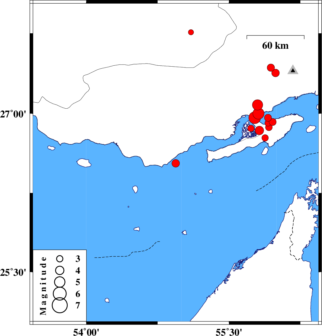
2009/01/05
|
02:23:20.8
|
05:53:20.8
| 26.53 | 54.94 | 16 |
ML:3.7
|
Persian Gulf, 9 km Bandar-e lengeh | |
|
|
2009/01/03
|
09:01:24.8
|
12:31:24.8
| 27.76 | 55.1 | 18 |
ML:2.6
|
75 km East of Lar, Fars Province | |
|
|
2008/12/27
|
22:58:43.9
|
02:28:43.9
| 26.86 | 55.73 | 15 |
ML:3.1
|
Persian Gulf, 53 km West of Qeshm | |
|
|
2008/12/27
|
20:29:02.9
|
23:59:02.9
| 27.43 | 55.94 | 14 |
ML:3.5
|
43 km North-West of Bandar-e abbas, Hormozgan Province | |
|
|
2008/12/15
|
18:37:20.7
|
22:07:20.7
| 26.77 | 55.88 | 15 |
ML:3.1
|
Persian Gulf, 42 km South-West of Qeshm | |
|
|
2008/12/11
|
05:42:07.3
|
09:12:07.3
| 26.84 | 55.82 | 6 |
ML:4.1
|
Persian Gulf, 46 km South-West of Qeshm | |
|
|
2008/12/09
|
15:09:27.4
|
18:39:27.4
| 27.08 | 55.8 | 15 |
ML:5
|
48 km North-West of Qeshm, Hormozgan Province | |
|
|
2008/12/08
|
14:41:44.1
|
18:11:44.1
| 27 | 55.81 | 2 |
Mb:5.3
|
Persian Gulf, 45 km West of Qeshm | |
|
|
2008/12/08
|
06:44:07.3
|
10:14:07.3
| 26.96 | 55.91 | 2 |
ML:3.4
|
Persian Gulf, 35 km West of Qeshm | |
|
|
2008/12/08
|
01:50:30.7
|
05:20:30.7
| 26.92 | 55.96 | 3 |
ML:3.4
|
Persian Gulf, 31 km West of Qeshm | |
|
|
2008/12/07
|
16:22:08.4
|
19:52:08.4
| 26.91 | 55.91 | 3 |
ML:3
|
Persian Gulf, 35 km West of Qeshm | |
|
|
2008/12/07
|
14:31:24.7
|
18:01:24.7
| 26.87 | 55.92 | 2 |
ML:3.3
|
Persian Gulf, 36 km West of Qeshm | |
|
|
2008/12/07
|
13:41:49.5
|
17:11:49.5
| 27.38 | 55.99 | 14 |
ML:3.6
|
36 km North-West of Bandar-e abbas, Hormozgan Province | |
|
|
2008/12/07
|
13:36:20.8
|
17:06:20.8
| 26.96 | 55.77 | 11 |
Mb:5.6
|
Persian Gulf, 49 km West of Qeshm | |