Home / Recent Earthquakes

| Prel. Rep. | Date | Time(UTC) | Time(Local) | Lat. | Lon. | Depth | Mag. | Region | Waveform |
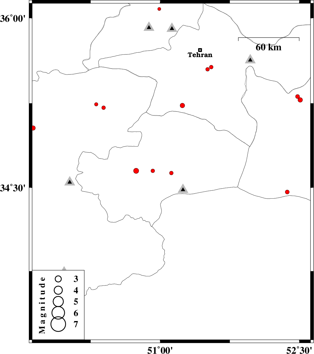
| 2015/03/17 | 18:17:15.8 | 21:47:15.8 | 34.63 | 51.12 | 40 | ML:1.8 | Qom Province, 23 km East of Qom | ||
| 2015/03/16 | 19:56:00.3 | 23:26:00.3 | 35.28 | 52.51 | 14 | ML:2.3 | Semnan Province, 17 km East of Garmsar | ||
| 2015/03/16 | 19:43:40.2 | 23:13:40.2 | 36.08 | 50.99 | 10 | ML:1.6 | Tehran Province, 31 km North of Karaj | ||
| 2015/03/12 | 08:49:09.0 | 12:19:09.0 | 35.57 | 51.55 | 14 | ML:1.9 | Tehran Province, 11 km East of Rey | ||
| 2015/03/06 | 14:29:34.9 | 17:59:34.9 | 35.21 | 50.39 | 14 | ML:1.9 | Markazi Province, 20 km North of Saveh | ||
| 2015/03/06 | 13:32:27.2 | 17:02:27.2 | 35.24 | 50.31 | 46 | ML:1.7 | Markazi Province, 25 km North of Saveh | ||
| 2015/03/03 | 08:33:16.1 | 12:03:16.1 | 35.55 | 51.51 | 17 | ML:1.9 | Tehran Province, 9 km Rey | ||
| 2015/03/03 | 08:31:24.1 | 12:01:24.1 | 34.46 | 52.37 | 14 | ML:2 | Semnan Province, 85 km South of Garmsar | ||
| 2015/02/25 | 03:26:58.6 | 06:56:58.6 | 34.65 | 50.92 | 15 | ML:1.9 | Qom Province, 5 km Qom | ||
| 2015/02/24 | 22:51:12.2 | 02:21:12.2 | 35.03 | 49.63 | 37 | ML:2.2 | Markazi Province, 52 km North-West of Tafresh | ||
| 2015/02/23 | 22:34:59.4 | 02:04:59.4 | 35.31 | 52.48 | 18 | ML:2 | Semnan Province, 16 km East of Garmsar | ||
| 2015/02/19 | 10:07:27.8 | 13:37:27.8 | 34.65 | 50.74 | 29 | ML:2.5 | Qom Province, 11 km West of Qom | ||
| 2015/02/18 | 20:06:24.5 | 23:36:24.5 | 35.23 | 51.24 | 14 | ML:2.2 | Tehran Province, 39 km South of Eslamshahr |