
Home / Updated Fault Map of Iran
The relationship between faults and earthquakes is a significant topic among geologists and seismologists. The scientific belief about the occurrence of tectonic earthquakes is based on the concept of the elastic rebound theory. According to the elastic rebound theory, the source of seismic energy in an earthquake is the sudden release of energy accumulated from elastic deformations in the Earth’s crust. This release of energy is accompanied by the sudden shear rupture of part of the Earth’s crust along what is called a fault. Therefore, the concept of faulting as an energy source for such earthquakes has become a general concept. As a result, identifying active faults and determining their seismic potential is the responsibility of geologists and seismologists, both for understanding the active tectonics of a region and for assessing earthquake hazards. Consequently, active fault maps (at appropriate scales) are widely used for research and education in various fields such as geomorphology, geology, geophysics, earthquake engineering, and civil engineering, making their preparation essential.
The first criterion for classifying active faults is the presence of evidence of activity in the present time on a geological scale. Generally, faults that have been associated with at least one seismic event during the Holocene (the last 11,000 years) or more events during the late Quaternary (the last 125,000 years) are called active faults.
To identify active faults, the following characteristics can be referenced:
– Historical Accounts
Reviewing historical accounts such as manuscripts, ancient personal notes, newspapers, and travelogues can help identify seismically active areas.
– Seismological Records
Any seismic activity recorded along faults, such as minor seismic events or large earthquakes, indicates the activity of that fault segment.
– Geological Features
Generally, active faults cause displacement of surface features and the creation of geomorphological markers along fault lines. Some of the most important markers include fault scarps, offset alluvial fans, triangular facets along the fault, displaced streams, pressure ridges, and displaced Quaternary deposits.
After identifying active faults based on the above criteria, they can be divided into three categories:
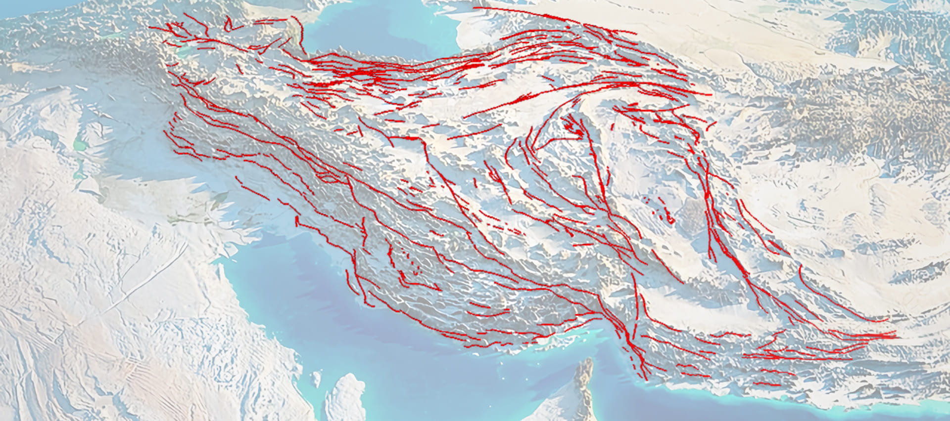
Thus, in 2003, IIEES prepared and published a map of active faults in Iran based on the above definitions and classifications. The second version of this map, updated in 2011, not only contains the latest information on active faults in Iran but also includes digital files of the faults with available data for each fault, including strike, dip, rake, mechanism, slip rate, seismic history, etc., available to the public on CD.
The active faults of Iran are direct indicators of the current deformation of the crust in Iran, resulting from the continental collision between the Arabian and Eurasian plates. Although the active faults in the Zagros are blind, the focal mechanism of earthquakes in this region indicates the presence of reverse faults (with a northwest-southeast strike) and strike-slip faults (with a north-south strike) along the basement. In other regions of Iran, most active faults reach the surface. The focal mechanism of earthquakes in the eastern and central parts of Iran indicates the dominance of strike-slip faults in a transpressive regime. Although the active faults in the Azerbaijan region are also of the strike-slip type, it seems that some of them have developed in a transpressive regime. In the Alborz and Kopet Dagh regions, fault zones are relatively wide and dense, making it difficult to identify individual and distinct active faults. Finally, except for the developed terraces along the coasts of the Oman Sea, our information about active faults in the Makran region is limited.
(Image: Masoumeh Rakhshandeh)