
Magnitude |
2.6 |
| Date & Time (UTC) | 2016-02-15 14:23:01.8 |
| Date & Time (Local) | 1394/11/26 17:53:01.8 |
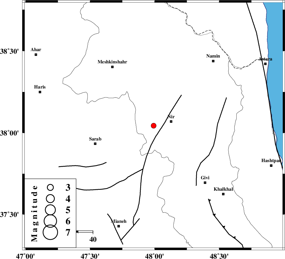
| Location | Lat:38.044 Lon: 47.992 |
| Region | Ardebil Province, 12 km -West of Nir |
Nearest Cities |
|
| 9 km North of Qarehshiran, Ardebil Province | |
| 11 km of Eslamabad, Ardebil Province | |
| 12 km West of Nir, Ardebil Province | |
| 15 km West of Rezaqoli qeshlaq, Ardebil Province | |
| 16 km South West of Varniab, Ardebil Province | |
| Depth | 16 km |
| Agency | |
Faults within 150 km: |
|
| BOZQUSH (Length: 70 km) , Distance to epicenter: 8 km | |
| SANGAVAR_F (Length: 61 km) , Distance to epicenter: 41 km | |
| MASULEL_F (Length: 90 km) , Distance to epicenter: 62 km | |
| Number of Phases | 6 |
| RMS | 0.2 |
| Number of Stations | 4 |
| Error in Latitude | >1.2 km |
| Error in Longitude | 8 km |
| Error in Depth | 8.5 km |
Download waveform in seisan format
to download seisan software Click here
to access information about IIEES stations Click here
Amplitude | ||||||||
| UID | Agency | Station | Component | Amplitude | Period | Arrival Time | Proccessing Time | Signal Clip |
| 104370 | IIEES | GRMI | E | 230.8 | 0.1 | 2016-02-15 14:23:28 | 2016-02-16 05:34:00 | n |
| 104371 | IIEES | ZNJK | N | 56.2 | 0.25 | 2016-02-15 14:23:55 | 2016-02-16 05:34:00 | n |
| 104372 | IIEES | ZNJK | E | 98.1 | 0.35 | 2016-02-15 14:23:55 | 2016-02-16 05:34:00 | n |
Phase | ||||||||||||
| Agency | Station | Component | Phase Type | Phase Quality | First Motion | Observed Arrival Time | Time Residual | Loc. Flag | Input Weight | Distance | Azimuth | |
| IIEES | GRMI | Z | Pg | E | 2016-02-15 14:23:16 | 0.28 | y | 85.4 | 354 | |||
| IIEES | GRMI | N | Sg | E | 2016-02-15 14:23:27 | -0.21 | y | 85.4 | 354 | |||
| IIEES | ZNJK | Z | Pg | E | 2016-02-15 14:23:29 | -0.03 | y | 164 | 158 | |||
| IIEES | SNGE | Z | Pn | E | 2016-02-15 14:23:52 | 2.07 | n | 4 | 333 | 190 | ||
| IIEES | SNGE | N | Sg | E | 2016-02-15 14:24:35 | -0.03 | y | 333 | 190 | |||
| IIEES | CHTH | Z | Pn | E | 2016-02-15 14:23:55 | -0.01 | y | 366 | 129 | |||