
Magnitude |
2.4 |
| Date & Time (UTC) | 2018-01-26 00:38:32.7 |
| Date & Time (Local) | 1396/11/6 04:08:32.7 |
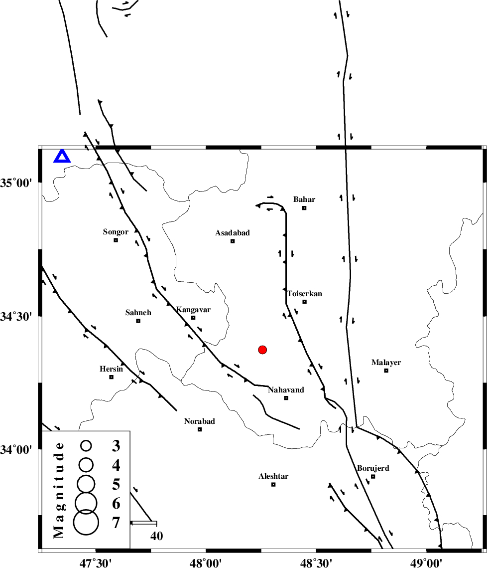
| Location | Lat:34.373 Lon: 48.256 |
| Region | Hamedan Province, 22 km North-West of Nahavand |
Nearest Cities |
|
| 9 km North of Firuzan, Hamedan Province | |
| 13 km South of Farsang, Hamedan Province | |
| 15 km North East of Shahrak, Hamedan Province | |
| 16 km West of Miyandeh, Hamedan Province | |
| 17 km North of Barzul, Hamedan Province | |
| Depth | 15 km |
| Agency | |
Faults within 150 km: |
|
| NAHAVAND_F (Length: 102 km) , Distance to epicenter: 8 km | |
| SAHANEH_F (Length: 77 km) , Distance to epicenter: 18 km | |
| DINEHVAR_F (Length: 46 km) , Distance to epicenter: 43 km | |
| Number of Phases | 8 |
| RMS | 0.5 |
| Number of Stations | 7 |
| Error in Latitude | >6 km |
| Error in Longitude | 3.9 km |
| Error in Depth | 8.6 km |
Download waveform in seisan format
to download seisan software Click here
to access information about IIEES stations Click here
Amplitude | ||||||||
| UID | Agency | Station | Component | Amplitude | Period | Arrival Time | Proccessing Time | Signal Clip |
| 127497 | IIEES | ILBA | N | 29 | 0.73 | 2018-01-26 00:39:37 | 2018-01-27 08:41:00 | n |
| 127498 | IIEES | ILBA | E | 37.2 | 0.69 | 2018-01-26 00:39:38 | 2018-01-27 08:41:00 | n |
| 127499 | IIEES | GHVR | E | 16.5 | 0.48 | 2018-01-26 00:40:01 | 2018-01-27 08:41:00 | n |
| 127500 | IIEES | GHVR | N | 12.4 | 0.48 | 2018-01-26 00:40:03 | 2018-01-27 08:41:00 | n |
Phase | ||||||||||||
| Agency | Station | Component | Phase Type | Phase Quality | First Motion | Observed Arrival Time | Time Residual | Loc. Flag | Input Weight | Distance | Azimuth | |
| IIEES | SNGE | Z | Pg | E | 2018-01-26 00:38:51 | -0.8 | y | 115 | 314 | |||
| IIEES | ASAO | Z | Pg | E | 2018-01-26 00:38:59 | -0.08 | y | 164 | 83 | |||
| IIEES | KHMZ | Z | Pg | E | 2018-01-26 00:39:00 | -0.65 | y | 173 | 114 | |||
| IIEES | ILBA | Z | Pn | E | 2018-01-26 00:39:05 | -0.13 | y | 207 | 247 | |||
| IIEES | ILBA | E | Sg | E | 2018-01-26 00:39:31 | 0.35 | y | 207 | 247 | |||
| IIEES | ZNJK | Z | Pn | E | 2018-01-26 00:39:13 | 0.61 | y | 258 | 9 | |||
| IIEES | GHVR | Z | Pn | E | 2018-01-26 00:39:15 | 0.7 | y | 275 | 87 | |||
| IIEES | SRSL | Z | Pn | E | 2018-01-26 00:39:21 | 0.03 | y | 328 | 309 | |||