
Magnitude |
3 |
| Date & Time (UTC) | 2018-02-20 10:01:24.5 |
| Date & Time (Local) | 1396/12/1 13:31:24.5 |
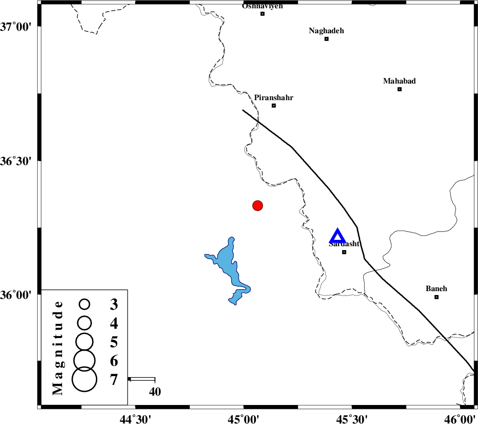
| Location | Lat:36.332 Lon: 45.064 |
| Region | Iraq, 42 km South of Piranshahr |
Nearest Cities |
|
| 28 km West of Mirabad, Azarbaijan Gharbi Province | |
| 29 km South West of Kavir, Azarbaijan Gharbi Province | |
| 33 km North West of Bivaran-e sofla, Azarbaijan Gharbi Province | |
| 34 km South West of Chiyaneh, Azarbaijan Gharbi Province | |
| 37 km North West of Felas, Azarbaijan Gharbi Province | |
| Depth | 17 km |
| Agency | |
Faults within 150 km: |
|
| PIRANSHAHR_F (Length: 253 km) , Distance to epicenter: 28 km | |
| HZF4 (Length: 492 km) , Distance to epicenter: 100 km | |
| Number of Phases | 6 |
| RMS | 0.3 |
| Number of Stations | 4 |
| Error in Latitude | >6.9 km |
| Error in Longitude | 9.6 km |
| Error in Depth | 7.1 km |
Download waveform in seisan format
to download seisan software Click here
to access information about IIEES stations Click here
Amplitude | ||||||||
| UID | Agency | Station | Component | Amplitude | Period | Arrival Time | Proccessing Time | Signal Clip |
| 128864 | IIEES | ILBA | E | 46.6 | 0.52 | 2018-02-20 10:02:57 | 2018-02-21 08:32:00 | n |
| 128865 | IIEES | ILBA | N | 40.8 | 0.58 | 2018-02-20 10:03:00 | 2018-02-21 08:32:00 | n |
Phase | ||||||||||||
| Agency | Station | Component | Phase Type | Phase Quality | First Motion | Observed Arrival Time | Time Residual | Loc. Flag | Input Weight | Distance | Azimuth | |
| IIEES | SRSL | Z | Pg | E | 2018-02-20 10:01:31 | 0 | y | 35.8 | 112 | |||
| IIEES | SRSL | N | Sg | E | 2018-02-20 10:01:36 | 0.11 | y | 35.8 | 112 | |||
| IIEES | SNGE | Z | Pn | E | 2018-02-20 10:02:03 | 0.6 | y | 248 | 123 | |||
| IIEES | SNGE | N | Sg | E | 2018-02-20 10:02:34 | -0.19 | y | 248 | 123 | |||
| IIEES | ILBA | Z | Pn | E | 2018-02-20 10:02:11 | -0.26 | y | 318 | 161 | |||
| IIEES | ZNJK | Z | Pn | E | 2018-02-20 10:02:12 | -0.32 | y | 327 | 82 | |||