
Magnitude |
3.1 |
| Date & Time (UTC) | 2025-06-24 16:03:40.6 |
| Date & Time (Local) | 1404/4/3 19:33:40.6 |
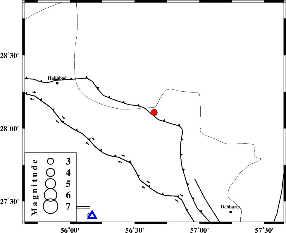
| Location | Lat:28.109 Lon: 56.65 |
| Region | Hormozgan Province, 77 km South-East of Hajiabad |
Nearest Cities |
|
| 34 km South West of Sarkhan, Kerman Province | |
| 42 km North East of Fareqan, Hormozgan Province | |
| 46 km South East of Arzuieeh, Kerman Province | |
| 47 km South East of Shahmaran, Kerman Province | |
| 61 km North West of Faryab, Kerman Province | |
| Depth | 17 km |
| Agency | |
Faults within 150 km: |
|
| MAIN_ZAGROS_R_F (Length: 1106 km) , Distance to epicenter: 2 km | |
| HZF2 (Length: 437 km) , Distance to epicenter: 42 km | |
| ZENDAN_MINAB_F_Z1 (Length: 183 km) , Distance to epicenter: 59 km | |
| Number of Phases | 6 |
| RMS | 0.7 |
| Number of Stations | 6 |
| Error in Latitude | >5.2 km |
| Error in Longitude | 5.2 km |
| Error in Depth | 999 km |
Download waveform in seisan format
to download seisan software Click here
to access information about IIEES stations Click here
Amplitude | ||||||||
| UID | Agency | Station | Component | Amplitude | Period | Arrival Time | Proccessing Time | Signal Clip |
| 198579 | IIEES SC | UOSS | Z | 0.05 | 1 | 2025-06-24 16:04:32 | 2025-07-01 06:38:00 | n |
| 198580 | IIEES SC | BSRN | Z | 0.04 | 1 | 2025-06-24 16:04:49 | 2025-07-01 06:38:00 | n |
| 198581 | IIEES SC | NASN | Z | 0.01 | 1 | 2025-06-24 16:05:07 | 2025-07-01 06:38:00 | n |
Phase | ||||||||||||
| Agency | Station | Component | Phase Type | Phase Quality | First Motion | Observed Arrival Time | Time Residual | Loc. Flag | Input Weight | Distance | Azimuth | |
| IIEES SC | KRBR | Z | EPn | E | 2025-06-24 16:04:14 | 0.7 | y | 0 | 208 | 3 | ||
| IIEES SC | UOSS | Z | EPn | E | 2025-06-24 16:04:32 | 0.8 | y | 0 | 353 | 187 | ||
| IIEES SC | GHIR | Z | EPn | E | 2025-06-24 16:04:32 | -0.6 | y | 0 | 360 | 273 | ||
| IIEES SC | IRSR | Z | EPn | E | 2025-06-24 16:04:41 | -0.6 | y | 0 | 435 | 107 | ||
| IIEES SC | BSRN | Z | EPn | E | 2025-06-24 16:04:49 | 0.8 | y | 0 | 490 | 29 | ||
| IIEES SC | NASN | Z | EPn | E | 2025-06-24 16:05:07 | -0.3 | y | 0 | 638 | 325 | ||