
Magnitude |
4.2 |
| Date & Time (UTC) | 2013-02-06 16:10:12.9 |
| Date & Time (Local) | 1391/11/18 19:40:12.9 |
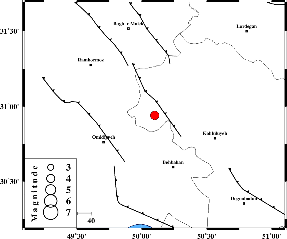
| Location | Lat:30.94 Lon: 50.1 |
| Region | Kohkiluieh va boyerahmad Province, 40 km North-West of Behbahan |
Nearest Cities |
|
| 23 km North East of Jolaki, Khoozestan Province | |
| 25 km North East of Jayzan, Khoozestan Province | |
| 27 km North of Dodange-ye bozorg, Khoozestan Province | |
| 31 km West of Lendeh, Kohkiluieh va boyerahmad Province | |
| 37 km North East of Aghajari, Khoozestan Province | |
| Depth | 14 km |
| Agency | |
Faults within 150 km: |
|
| MFF4 (Length: 62 km) , Distance to epicenter: 7 km | |
| MFF2 (Length: 205 km) , Distance to epicenter: 40 km | |
| AGHAJARI_F (Length: 88 km) , Distance to epicenter: 41 km | |
| Number of Phases | 5 |
| RMS | 0 |
| Number of Stations | 5 |
| Error in Latitude | >1.5 km |
| Error in Longitude | 4 km |
| Error in Depth | 5.6 km |
Download waveform in seisan format
to download seisan software Click here
to access information about IIEES stations Click here
Amplitude | ||||||||
| UID | Agency | Station | Component | Amplitude | Period | Arrival Time | Proccessing Time | Signal Clip |
| 87803 | IIEES | SHGR | N | 5489.2 | 0.44 | 2013-02-06 16:11:07 | 2013-02-06 04:31:00 | n |
| 87804 | IIEES | SHGR | E | 3220.3 | 0.24 | 2013-02-06 16:11:09 | 2013-02-06 04:31:00 | n |
| 87805 | IIEES | SNGE | E | 115.7 | 0.48 | 2013-02-06 16:12:22 | 2013-02-06 04:31:00 | n |
| 87806 | IIEES | SNGE | N | 125.7 | 0.36 | 2013-02-06 16:12:24 | 2013-02-06 04:31:00 | n |
Phase | ||||||||||||
| Agency | Station | Component | Phase Type | Phase Quality | First Motion | Observed Arrival Time | Time Residual | Loc. Flag | Input Weight | Distance | Azimuth | |
| IIEES | SHGR | Z | Pg | E | 2013-02-06 16:10:42 | -0.01 | y | 179 | 317 | |||
| IIEES | AHRM | Z | Pn | E | 2013-02-06 16:10:52 | 0 | y | 257 | 153 | |||
| IIEES | KHMZ | Z | Pn | E | 2013-02-06 16:10:59 | 0.04 | y | 311 | 358 | |||
| IIEES | KHMZ | E | Sg | E | 2013-02-06 16:11:40 | -0.02 | y | 311 | 358 | |||
| IIEES | GHIR | Z | Pn | E | 2013-02-06 16:11:11 | -0.02 | y | 405 | 136 | |||