
Magnitude |
3.1 |
| Date & Time (UTC) | 2013-07-24 08:04:53.1 |
| Date & Time (Local) | 1392/5/2 12:34:53.1 |
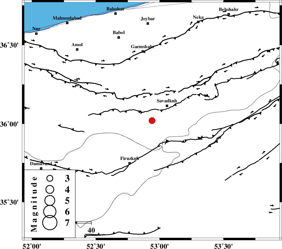
| Location | Lat:36.02 Lon: 52.94 |
| Region | Mazandaran Province, 15 km West of Pol-E-Sefid |
Nearest Cities |
|
| 8 km of Elahband, Mazandaran Province | |
| 11 km East of Alasht, Mazandaran Province | |
| 13 km West of Shurmast-e peyrudbar, Mazandaran Province | |
| 15 km West of Pol-E-Sefid, Mazandaran Province | |
| 17 km South of Zirab, Mazandaran Province | |
| Depth | 14 km |
| Agency | |
Faults within 150 km: |
|
| N_ALBORZ_F (Length: 360 km) , Distance to epicenter: 19 km | |
| ATARI_F (Length: 185 km) , Distance to epicenter: 36 km | |
| KHAZAR_F (Length: 523 km) , Distance to epicenter: 45 km | |
| Number of Phases | 8 |
| RMS | 0.3 |
| Number of Stations | 6 |
| Error in Latitude | >4.7 km |
| Error in Longitude | 8.3 km |
| Error in Depth | 9.9 km |
Download waveform in seisan format
to download seisan software Click here
to access information about IIEES stations Click here
Amplitude | ||||||||
| UID | Agency | Station | Component | Amplitude | Period | Arrival Time | Proccessing Time | Signal Clip |
| 89985 | IIEES | THKV | E | 134.6 | 0.33 | 2013-07-24 08:05:53 | 2013-07-24 09:36:00 | n |
| 89986 | IIEES | GHVR | E | 209.8 | 0.37 | 2013-07-24 08:06:04 | 2013-07-24 09:36:00 | n |
| 89987 | IIEES | GHVR | N | 147.2 | 0.57 | 2013-07-24 08:06:05 | 2013-07-24 09:36:00 | n |
| 89988 | IIEES | ASAO | E | 49.6 | 0.6 | 2013-07-24 08:06:21 | 2013-07-24 09:36:00 | n |
Phase | ||||||||||||
| Agency | Station | Component | Phase Type | Phase Quality | First Motion | Observed Arrival Time | Time Residual | Loc. Flag | Input Weight | Distance | Azimuth | |
| IIEES | CHTH | Z | Pg | E | 2013-07-24 08:05:20 | 0.52 | y | 164 | 266 | |||
| IIEES | THKV | Z | Pg | E | 2013-07-24 08:05:23 | -0.5 | y | 187 | 267 | |||
| IIEES | THKV | E | Sg | E | 2013-07-24 08:05:46 | -0.11 | y | 187 | 267 | |||
| IIEES | GHVR | Z | Pn | E | 2013-07-24 08:05:29 | 0.14 | y | 230 | 223 | |||
| IIEES | GHVR | E | Sg | E | 2013-07-24 08:05:58 | 0.04 | y | 230 | 223 | |||
| IIEES | ASAO | Z | Pn | E | 2013-07-24 08:05:39 | 0.25 | y | 311 | 239 | |||
| IIEES | NASN | Z | Pn | E | 2013-07-24 08:05:45 | -0.27 | y | 357 | 182 | |||
| IIEES | KHMZ | Z | Pn | E | 2013-07-24 08:05:47 | -0.09 | y | 371 | 228 | |||