
Magnitude |
3.5 |
| Date & Time (UTC) | 2013-09-03 20:04:58.5 |
| Date & Time (Local) | 1392/6/13 00:34:58.5 |
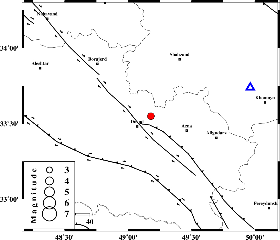
| Location | Lat:33.55 Lon: 49.18 |
| Region | Lorestan Province, 12 km East of Dorud |
Nearest Cities |
|
| 5 km North of Zhan, Lorestan Province | |
| 11 km North of Heshmatabad, Lorestan Province | |
| 13 km North East of Dorud, Lorestan Province | |
| 17 km North West of Darband, Lorestan Province | |
| 19 km North East of Void, Lorestan Province | |
| Depth | 14 km |
| Agency | |
Faults within 150 km: |
|
| MAIN_ZAGROS_R_F (Length: 1106 km) , Distance to epicenter: 7 km | |
| DORUD (Length: 100 km) , Distance to epicenter: 11 km | |
| HZF4 (Length: 492 km) , Distance to epicenter: 40 km | |
| Number of Phases | 6 |
| RMS | 0.1 |
| Number of Stations | 7 |
| Error in Latitude | >5.7 km |
| Error in Longitude | 2.7 km |
| Error in Depth | 5.1 km |
Download waveform in seisan format
to download seisan software Click here
to access information about IIEES stations Click here
Amplitude | ||||||||
| UID | Agency | Station | Component | Amplitude | Period | Arrival Time | Proccessing Time | Signal Clip |
| 90447 | IIEES | KHMZ | N | 1666.1 | 0.4 | 2013-09-03 20:05:24 | 2013-09-03 09:30:00 | n |
| 90448 | IIEES | ASAO | E | 1829.2 | 0.48 | 2013-09-03 20:05:40 | 2013-09-03 09:30:00 | n |
| 90449 | IIEES | GHVR | E | 384.6 | 0.48 | 2013-09-03 20:06:10 | 2013-09-03 09:30:00 | n |
| 90450 | IIEES | GHVR | N | 293.8 | 0.68 | 2013-09-03 20:06:13 | 2013-09-03 09:30:00 | n |
| 90451 | IIEES | DAMV | E | 145.5 | 0.52 | 2013-09-03 20:06:40 | 2013-09-03 09:30:00 | n |
Phase | ||||||||||||
| Agency | Station | Component | Phase Type | Phase Quality | First Motion | Observed Arrival Time | Time Residual | Loc. Flag | Input Weight | Distance | Azimuth | |
| IIEES | KHMZ | Z | Pg | E | 2013-09-03 20:05:11 | 0.04 | y | 75.8 | 74 | |||
| IIEES | KHMZ | N | Sg | E | 2013-09-03 20:05:21 | -0.03 | y | 75.8 | 74 | |||
| IIEES | ASAO | Z | Pg | E | 2013-09-03 20:05:21 | -0.1 | y | 136 | 35 | |||
| IIEES | SNGE | Z | Pn | E | 2013-09-03 20:05:36 | -0.1 | y | 240 | 316 | |||
| IIEES | CHTH | Z | Pn | E | 2013-09-03 20:05:45 | 0.06 | y | 317 | 34 | |||
| IIEES | ZNJK | Z | Pn | E | 2013-09-03 20:05:49 | 0.15 | y | 349 | 353 | |||