
Magnitude |
3.1 |
| Date & Time (UTC) | 2014-09-17 12:32:18.4 |
| Date & Time (Local) | 1393/6/26 17:02:18.4 |
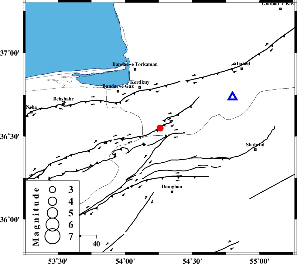
| Location | Lat:36.55 Lon: 54.26 |
| Region | Golestan Province, 30 km South-East of Kordkuy |
Nearest Cities |
|
| 17 km West of Cheharbagh, Golestan Province | |
| 21 km South West of Naharkhoran, Golestan Province | |
| 27 km South East of Sarkalateh, Golestan Province | |
| 30 km South East of Kordkuy, Golestan Province | |
| 33 km South of Lamsak, Golestan Province | |
| Depth | 14 km |
| Agency | |
Faults within 150 km: |
|
| N_ALBORZ_F (Length: 360 km) , Distance to epicenter: 7 km | |
| ASTANEH_F (Length: 72 km) , Distance to epicenter: 8 km | |
| SHAVAR_F (Length: 87 km) , Distance to epicenter: 13 km | |
| Number of Phases | 8 |
| RMS | 0.1 |
| Number of Stations | 6 |
| Error in Latitude | >4.4 km |
| Error in Longitude | 2.7 km |
| Error in Depth | 4 km |
Download waveform in seisan format
to download seisan software Click here
to access information about IIEES stations Click here
Amplitude | ||||||||
| UID | Agency | Station | Component | Amplitude | Period | Arrival Time | Proccessing Time | Signal Clip |
| 93617 | IIEES | DAMV | E | 116.4 | 0.39 | 2014-09-17 12:33:26 | 2014-09-17 05:25:00 | n |
| 93618 | IIEES | THKV | N | 91.7 | 0.43 | 2014-09-17 12:33:47 | 2014-09-17 05:25:00 | n |
Phase | ||||||||||||
| Agency | Station | Component | Phase Type | Phase Quality | First Motion | Observed Arrival Time | Time Residual | Loc. Flag | Input Weight | Distance | Azimuth | |
| IIEES | DAMV | Z | Pn | E | 2014-09-17 12:32:54 | 0.1 | y | 230 | 244 | |||
| IIEES | DAMV | E | Sg | E | 2014-09-17 12:33:23 | -0.12 | y | 230 | 244 | |||
| IIEES | CHTH | Z | Pn | E | 2014-09-17 12:33:02 | -0.21 | y | 290 | 257 | |||
| IIEES | THKV | Z | Pn | E | 2014-09-17 12:33:04 | -0.01 | y | 312 | 258 | |||
| IIEES | GHVR | Z | Pn | E | 2014-09-17 12:33:10 | 0.16 | y | 357 | 231 | |||
| IIEES | GHVR | E | Sn | 2014-09-17 12:33:48 | 0.05 | y | 357 | 231 | ||||
| IIEES | TABS | Z | Pn | E | 2014-09-17 12:33:17 | -0.16 | y | 414 | 140 | |||
| IIEES | ASAO | Z | Pn | E | 2014-09-17 12:33:21 | 0.24 | y | 443 | 241 | |||