
Magnitude |
1.8 |
| Date & Time (UTC) | 2015-04-05 15:32:36.2 |
| Date & Time (Local) | 1394/1/16 20:02:36.2 |
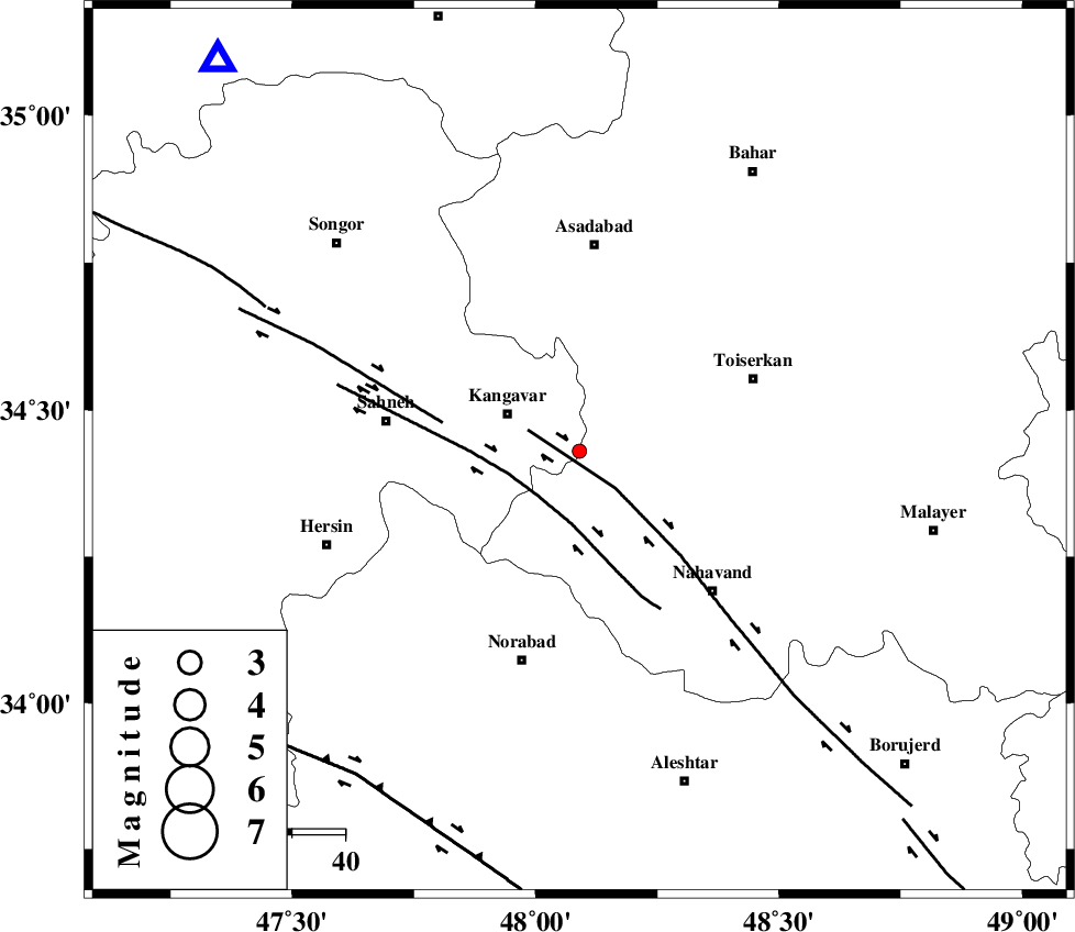
| Location | Lat:34.43 Lon: 48.09 |
| Region | Kermanshah Province, 15 km East of Kangavar |
Nearest Cities |
|
| 10 km North of Firuzan, Hamedan Province | |
| 10 km of Gudin, Kermanshah Province | |
| 14 km East of Karmanjan, Kermanshah Province | |
| 15 km East of Kangavar, Kermanshah Province | |
| 18 km North East of Sarab dehlor, Kermanshah Province | |
| Depth | 14 km |
| Agency | |
Faults within 150 km: |
|
| NAHAVAND_F (Length: 102 km) , Distance to epicenter: 10 km | |
| SAHANEH_F (Length: 77 km) , Distance to epicenter: 12 km | |
| DINEHVAR_F (Length: 46 km) , Distance to epicenter: 26 km | |
| Number of Phases | 5 |
| RMS | 0 |
| Number of Stations | 3 |
| Error in Latitude | >5.2 km |
| Error in Longitude | 2.4 km |
| Error in Depth | 5.7 km |
Download waveform in seisan format
to download seisan software Click here
to access information about IIEES stations Click here
Amplitude | ||||||||
| UID | Agency | Station | Component | Amplitude | Period | Arrival Time | Proccessing Time | Signal Clip |
| 95343 | IIEES | KHMZ | Z | 9.8 | 0.68 | 2015-04-05 15:33:40 | 2015-04-06 02:55:00 | n |
Phase | ||||||||||||
| Agency | Station | Component | Phase Type | Phase Quality | First Motion | Observed Arrival Time | Time Residual | Loc. Flag | Input Weight | Distance | Azimuth | |
| IIEES | SNGE | Z | Pg | E | 2015-04-05 15:32:53 | 0.03 | y | 100 | 318 | |||
| IIEES | SNGE | E | Sg | E | 2015-04-05 15:33:05 | -0.02 | y | 100 | 318 | |||
| IIEES | ASAO | Z | Pn | E | 2015-04-05 15:33:06 | 0.03 | y | 179 | 85 | |||
| IIEES | ASAO | E | Sg | E | 2015-04-05 15:33:27 | -0.01 | y | 179 | 85 | |||
| IIEES | KHMZ | Z | Pn | E | 2015-04-05 15:33:07 | -0.03 | y | 189 | 113 | |||