
Magnitude |
2.7 |
| Date & Time (UTC) | 2015-09-13 22:53:58.9 |
| Date & Time (Local) | 1394/6/23 03:23:58.9 |
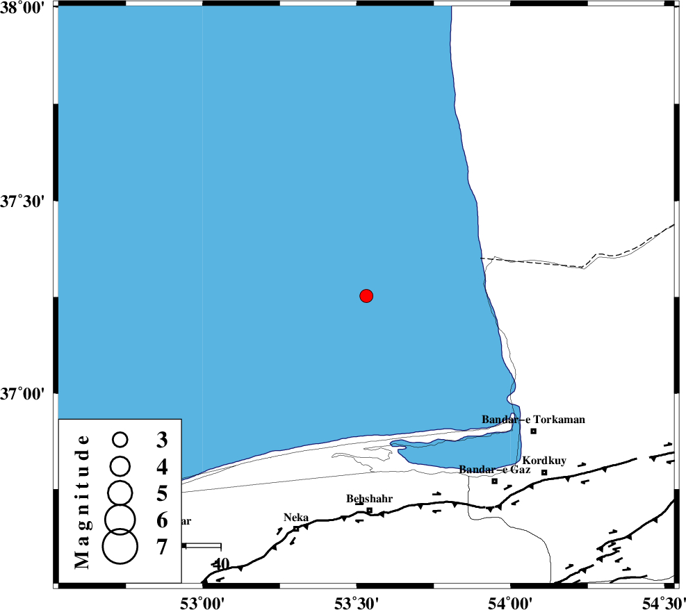
| Location | Lat:37.253 Lon: 53.531 |
| Region | Caspian Sea, 62 km North of Behshahr |
Nearest Cities |
|
| 52 km North West of Gomishtappeh, Golestan Province | |
| 53 km North East of Zaghmarz, Mazandaran Province | |
| 62 km North West of Bandar-e torkaman, Golestan Province | |
| 62 km North of Behshahr, Mazandaran Province | |
| 62 km North West of Lamrask, Mazandaran Province | |
| Depth | 14 km |
| Agency | |
Faults within 150 km: |
|
| KHAZAR_F (Length: 523 km) , Distance to epicenter: 62 km | |
| N_ALBORZ_F (Length: 360 km) , Distance to epicenter: 91 km | |
| SHAVAR_F (Length: 87 km) , Distance to epicenter: 109 km | |
| Number of Phases | 7 |
| RMS | 0.2 |
| Number of Stations | 6 |
| Error in Latitude | >7.3 km |
| Error in Longitude | 3.8 km |
| Error in Depth | 9.5 km |
Download waveform in seisan format
to download seisan software Click here
to access information about IIEES stations Click here
Amplitude | ||||||||
| UID | Agency | Station | Component | Amplitude | Period | Arrival Time | Proccessing Time | Signal Clip |
| 100922 | IIEES | MRVT | E | 53.6 | 0.17 | 2015-09-13 22:55:06 | 2015-09-14 06:47:00 | n |
| 100923 | IIEES | MRVT | N | 45.7 | 0.21 | 2015-09-13 22:55:11 | 2015-09-14 06:47:00 | n |
Phase | ||||||||||||
| Agency | Station | Component | Phase Type | Phase Quality | First Motion | Observed Arrival Time | Time Residual | Loc. Flag | Input Weight | Distance | Azimuth | |
| IIEES | DAMV | Z | Pn | E | 2015-09-13 22:54:35 | 0.35 | y | 228 | 218 | |||
| IIEES | MRVT | Z | Pn | E | 2015-09-13 22:54:35 | -0.1 | y | 231 | 78 | |||
| IIEES | SHRO | Z | Pn | E | 2015-09-13 22:54:39 | -0.03 | y | 261 | 121 | |||
| IIEES | CHTH | Z | Pn | E | 2015-09-13 22:54:39 | -0.25 | y | 262 | 236 | |||
| IIEES | CHTH | E | Sg | E | 2015-09-13 22:55:12 | -0.21 | y | 262 | 236 | |||
| IIEES | THKV | Z | Pn | E | 2015-09-13 22:54:41 | 0.28 | y | 280 | 239 | |||
| IIEES | TABS | Z | Pn | E | 2015-09-13 22:55:10 | -0.05 | y | 516 | 140 | |||