Home / Recent Earthquakes

| Prel. Rep. | Date | Time(UTC) | Time(Local) | Lat. | Lon. | Depth | Mag. | Region | Waveform |
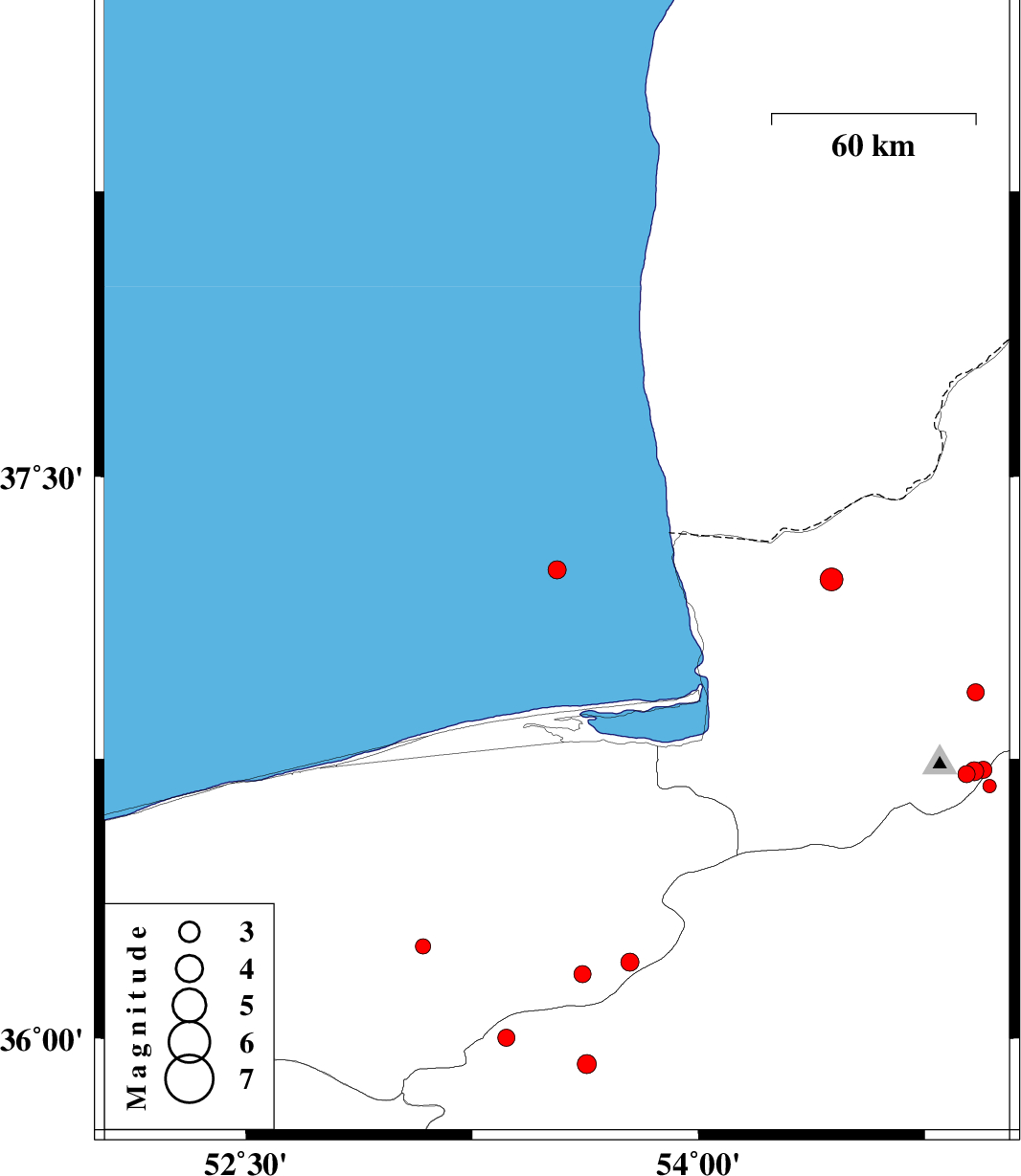
| 2015/09/13 | 22:53:58.9 | 03:23:58.9 | 37.253 | 53.531 | 14 | ML:2.7 | Caspian Sea, 62 km North of Behshahr | ||
| 2015/09/11 | 08:13:02.6 | 12:43:02.6 | 37.227 | 54.441 | 15 | ML:3.4 | Golestan Province, 24 km North of Aq Qaleh | ||
| 2015/09/09 | 20:50:19.0 | 01:20:19.0 | 36.247 | 53.086 | 18 | ML:2.3 | Mazandaran Province, 15 km North of Pol-E-Sefid | ||
| 2015/09/07 | 06:05:18.2 | 10:35:18.2 | 36.172 | 53.615 | 14 | ML:2.5 | Mazandaran Province, 58 km South of Behshahr | ||
| 2015/09/06 | 15:37:44.1 | 20:07:44.1 | 36.283 | 52.493 | 16 | ML:2.5 | Mazandaran Province, 24 km South-East of Amol | ||
| 2015/09/05 | 23:32:00.5 | 04:02:00.5 | 36.001 | 53.363 | 17 | ML:2.5 | Semnan Province, 30 km South-East of Pol-E-Sefid | ||
| 2015/09/05 | 20:11:49.2 | 00:41:49.2 | 36.234 | 52.467 | 14 | ML:3.2 | Mazandaran Province, 28 km South-East of Amol | ||
| 2015/09/03 | 21:10:34.5 | 01:40:34.5 | 36.677 | 54.965 | 14 | ML:2 | Semnan Province, 29 km North of Shahrud | ||
| 2015/08/29 | 21:58:12.5 | 02:28:12.5 | 36.708 | 54.888 | 14 | ML:2.6 | Golestan Province, 22 km South of Ali Abad | ||
| 2015/08/29 | 21:55:25.9 | 02:25:25.9 | 36.716 | 54.914 | 14 | ML:2.8 | Golestan Province, 21 km South of Ali Abad | ||
| 2015/08/29 | 01:46:33.7 | 06:16:33.7 | 35.768 | 52.069 | 14 | ML:2.4 | Mazandaran Province, 6 km of Damavand | ||
| 2015/08/28 | 00:57:18.2 | 05:27:18.2 | 35.93 | 53.63 | 15 | ML:2.8 | Semnan Province, 45 km North-East of Semnan | ||
| 2015/08/24 | 19:49:20.6 | 00:19:20.6 | 36.927 | 54.919 | 18 | ML:2.5 | Golestan Province, 5 km of Ali Abad | ||
| 2015/08/21 | 17:31:29.3 | 22:01:29.3 | 36.72 | 54.944 | 16 | ML:2.6 | Golestan Province, 22 km South of Ali Abad | ||
| 2015/08/17 | 12:03:05.7 | 16:33:05.7 | 36.205 | 53.772 | 14 | ML:2.7 | Mazandaran Province, 52 km -West of Damghan |