
Magnitude |
2.5 |
| Date & Time (UTC) | 2017-09-21 01:28:28.9 |
| Date & Time (Local) | 1396/6/30 05:58:28.9 |
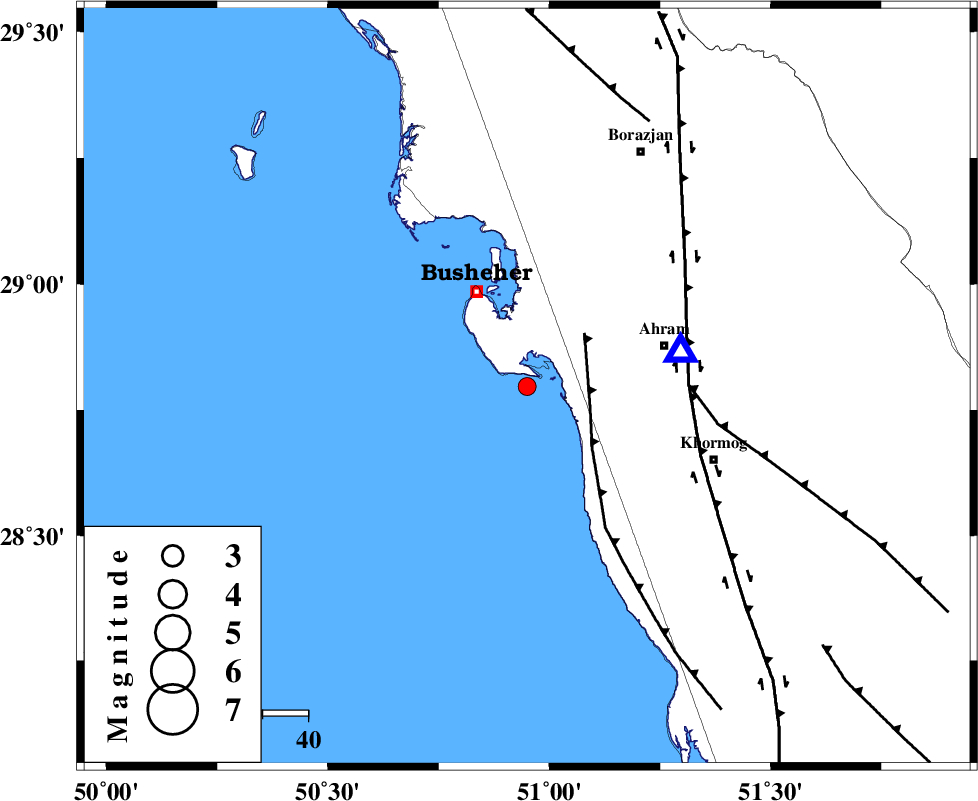
| Location | Lat:28.796 Lon: 50.95 |
| Region | Persian Gulf, 24 km South-East of Busheher |
Nearest Cities |
|
| 12 km North West of Delvar, Bushehr Province | |
| 23 km South of Choghadak, Bushehr Province | |
| 24 km South East of Busheher, Bushehr Province | |
| 32 km West of Ahram, Bushehr Province | |
| 34 km North West of Derazi, Bushehr Province | |
| Depth | 6 km |
| Agency | |
Faults within 150 km: |
|
| ZFF2 (Length: 84 km) , Distance to epicenter: 14 km | |
| BORAZJAN_F (Length: 168 km) , Distance to epicenter: 36 km | |
| MFF5 (Length: 74 km) , Distance to epicenter: 36 km | |
| Number of Phases | 5 |
| RMS | 0.1 |
| Number of Stations | 3 |
| Error in Latitude | >3.5 km |
| Error in Longitude | 5.3 km |
| Error in Depth | 6.9 km |
Download waveform in seisan format
to download seisan software Click here
to access information about IIEES stations Click here
Amplitude | ||||||||
| UID | Agency | Station | Component | Amplitude | Period | Arrival Time | Proccessing Time | Signal Clip |
| 119880 | IIEES | AHRM | E | 919.4 | 0.49 | 2017-09-21 01:28:44 | 2017-09-24 09:31:00 | n |
| 119881 | IIEES | AHRM | N | 555.8 | 0.37 | 2017-09-21 01:28:45 | 2017-09-24 09:31:00 | n |
| 119882 | IIEES | GHIR | N | 25.9 | 0.47 | 2017-09-21 01:29:36 | 2017-09-24 09:31:00 | n |
| 119883 | IIEES | GHIR | E | 30.4 | 0.82 | 2017-09-21 01:29:45 | 2017-09-24 09:31:00 | n |
| 119884 | IIEES | NASN | N | 4.1 | 0.39 | 2017-09-21 01:30:34 | 2017-09-24 09:31:00 | n |
Phase | ||||||||||||
| Agency | Station | Component | Phase Type | Phase Quality | First Motion | Observed Arrival Time | Time Residual | Loc. Flag | Input Weight | Distance | Azimuth | |
| IIEES | AHRM | Z | Pg | E | 2017-09-21 01:28:35 | -0.15 | y | 34.8 | 77 | |||
| IIEES | AHRM | N | Sg | E | 2017-09-21 01:28:39 | -0.03 | y | 34.8 | 77 | |||
| IIEES | GHIR | Z | Pn | E | 2017-09-21 01:29:03 | -0.09 | y | 207 | 105 | |||
| IIEES | GHIR | N | Sg | E | 2017-09-21 01:29:30 | 0.14 | y | 207 | 105 | |||
| IIEES | NASN | Z | Pn | E | 2017-09-21 01:29:37 | 0.19 | y | 478 | 21 | |||