Home / Recent Earthquakes

| Prel. Rep. | Date | Time(UTC) | Time(Local) | Lat. | Lon. | Depth | Mag. | Region | Waveform |
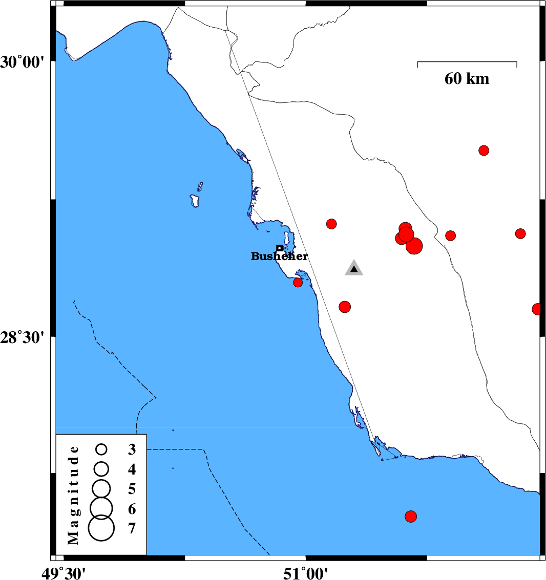
| 2017/09/21 | 01:28:28.9 | 05:58:28.9 | 28.796 | 50.95 | 6 | ML:2.5 | Persian Gulf, 24 km South-East of Busheher | ||
| 2017/09/16 | 05:16:21.3 | 09:46:21.3 | 29.515 | 52.103 | 14 | ML:2.8 | Fars Province, 43 km South-West of Shiraz | ||
| 2017/09/12 | 00:29:40.2 | 04:59:40.2 | 29.115 | 51.158 | 14 | ML:2.8 | Bushehr Province, 17 km South of Borazjan | ||
| 2017/09/10 | 23:17:26.8 | 03:47:26.8 | 28.663 | 51.241 | 26 | ML:3.3 | Bushehr Province, 13 km -West of Khormog | ||
| 2017/09/08 | 15:24:06.2 | 19:54:06.2 | 29.058 | 51.622 | 15 | ML:4.2 | Bushehr Province, 41 km North-East of Ahram | ||
| 2017/09/06 | 10:22:35.8 | 14:52:35.8 | 29.038 | 51.593 | 16 | ML:3.5 | Bushehr Province, 37 km North-East of Ahram | ||
| 2017/09/06 | 09:46:06.6 | 14:16:06.6 | 28.651 | 52.438 | 6 | ML:3.3 | Fars Province, 25 km South-West of Firuz Abad | ||
| 2017/09/04 | 23:55:59.5 | 04:25:59.5 | 29.051 | 51.897 | 14 | ML:2.8 | Fars Province, 27 km North-West of Farashband | ||
| 2017/09/04 | 10:02:34.6 | 14:32:34.6 | 29.089 | 51.617 | 15 | ML:3.7 | Bushehr Province, 42 km North-East of Ahram | ||
| 2017/09/03 | 12:48:59.1 | 17:18:59.1 | 28.996 | 51.671 | 13 | ML:4.7 | Bushehr Province, 42 km North-East of Ahram | ||
| 2017/09/01 | 05:41:54.9 | 10:11:54.9 | 29.062 | 52.33 | 7 | ML:2.8 | Fars Province, 32 km North-East of Farashband | ||
| 2017/08/28 | 10:48:57.7 | 15:18:57.7 | 27.51 | 51.651 | 15 | ML:3.2 | Persian Gulf, 54 km South-West of Bandar-e kangan |