
Magnitude |
4.2 |
| Date & Time (UTC) | 2025-07-28 07:46:55.0 |
| Date & Time (Local) | 1404/5/6 11:16:55.0 |
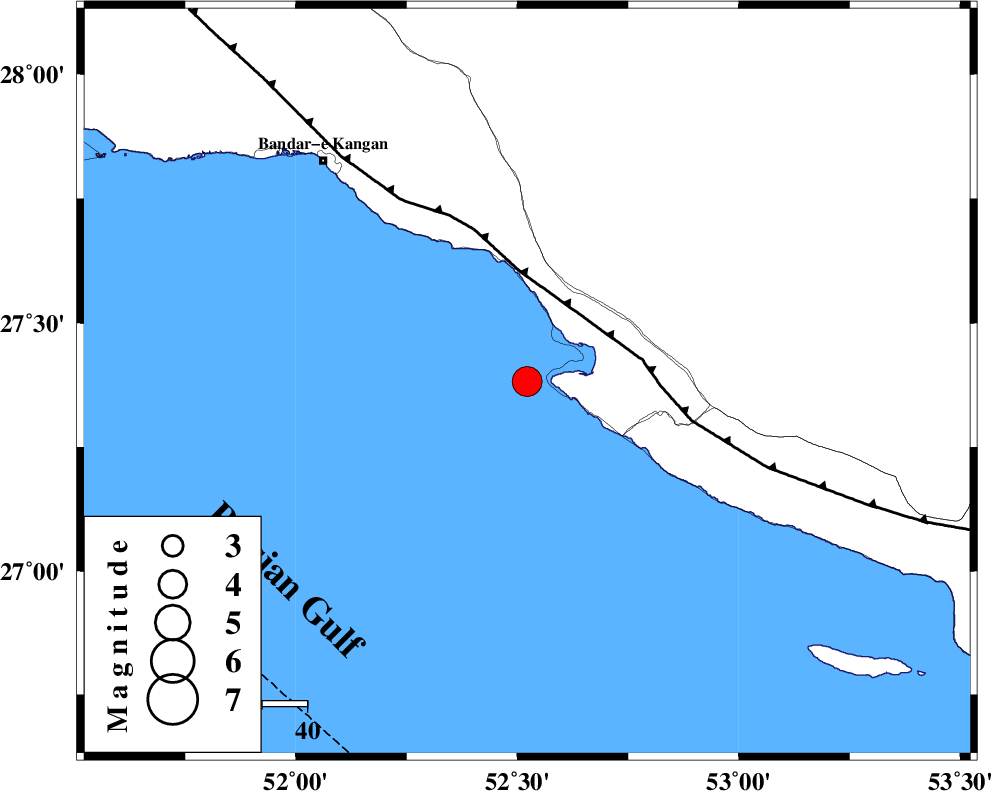
| Location | Lat:27.382 Lon: 52.522 |
| Region | Persian Gulf, 41 km South-West of Mehr |
Nearest Cities |
|
| 13 km of Bandar-e asaluyeh, Bushehr Province | |
| 26 km North West of Chah-e mobarak, Bushehr Province | |
| 34 km South West of Gallehdar, Fars Province | |
| 36 km South West of Ardavan-e olia, Fars Province | |
| 36 km South East of Bandar-e taheri, Bushehr Province | |
| Depth | 12 km |
| Agency | |
Faults within 150 km: |
|
| MFF3 (Length: 292 km) , Distance to epicenter: 25 km | |
| BORAZJAN_F (Length: 168 km) , Distance to epicenter: 114 km | |
| QIR_F (Length: 130 km) , Distance to epicenter: 121 km | |
| Number of Phases | 9 |
| RMS | 0.3 |
| Number of Stations | 9 |
| Error in Latitude | >2.2 km |
| Error in Longitude | 2.2 km |
| Error in Depth | 485.1 km |
Download waveform in seisan format
to download seisan software Click here
to access information about IIEES stations Click here
Amplitude | ||||||||
| UID | Agency | Station | Component | Amplitude | Period | Arrival Time | Proccessing Time | Signal Clip |
| 198742 | IIEES SC | UOSS | Z | 0.3 | 1 | 2025-07-28 07:48:00 | 2025-07-31 08:45:00 | n |
| 198743 | IIEES SC | NASN | Z | 0.1 | 1 | 2025-07-28 07:48:18 | 2025-07-31 08:45:00 | n |
| 198744 | IIEES SC | GHVR | Z | 0.2 | 1 | 2025-07-28 07:48:41 | 2025-07-31 08:45:00 | n |
| 198745 | IIEES SC | TABS | Z | 0.02 | 1 | 2025-07-28 07:48:44 | 2025-07-31 08:45:00 | n |
Phase | ||||||||||||
| Agency | Station | Component | Phase Type | Phase Quality | First Motion | Observed Arrival Time | Time Residual | Loc. Flag | Input Weight | Distance | Azimuth | |
| IIEES SC | UOSS | Z | EPn | E | 2025-07-28 07:48:00 | 0.4 | y | 0 | 456 | 126 | ||
| IIEES SC | KRBR | Z | EPn | E | 2025-07-28 07:48:02 | -3.1 | n | 4 | 505 | 55 | ||
| IIEES SC | YZKH | Z | EPn | E | 2025-07-28 07:47:46 | -29.7 | n | 4 | 590 | 20 | ||
| IIEES SC | NASN | Z | EPn | E | 2025-07-28 07:48:18 | 0.5 | y | 0 | 601 | 3 | ||
| IIEES SC | GHVR | Z | EPn | E | 2025-07-28 07:48:41 | 0 | y | 0 | 796 | 351 | ||
| IIEES SC | CHBR | Z | EPn | E | 2025-07-28 07:48:44 | -0.3 | y | 0 | 818 | 104 | ||
| IIEES SC | TABS | Z | EPn | E | 2025-07-28 07:48:44 | -0.5 | y | 0 | 823 | 32 | ||
| IIEES SC | RAYN | Z | EPn | E | 2025-07-28 07:48:45 | -0.2 | y | 0 | 825 | 239 | ||
| IIEES SC | IRSR | Z | EPn | E | 2025-07-28 07:48:45 | 0.1 | y | 0 | 828 | 93 | ||