Home / Recent Earthquakes

| Prel. Rep. | Date | Time(UTC) | Time(Local) | Lat. | Lon. | Depth | Mag. | Region | Waveform |
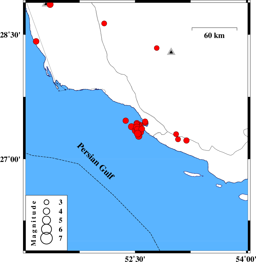
| 2025/07/28 | 20:09:03.3 | 23:39:03.3 | 27.464 | 52.373 | 12 | ML:3.5 | Persian Gulf, 41 km South of Jam | ||
| 2025/07/28 | 14:39:00.7 | 18:09:00.7 | 27.308 | 52.535 | 21 | ML:4.3 | Persian Gulf, 44 km South-West of Mehr | ||
| 2025/07/28 | 13:42:04.2 | 17:12:04.2 | 27.364 | 52.591 | 16 | ML:3.6 | Persian Gulf, 36 km South-West of Mehr | ||
| 2025/07/28 | 11:24:17.4 | 14:54:17.4 | 27.36 | 52.53 | 12 | ML:3.7 | Persian Gulf, 41 km South-West of Mehr | ||
| 2025/07/28 | 10:53:18.7 | 14:23:18.7 | 27.306 | 52.54 | 21 | ML:4 | Persian Gulf, 44 km South-West of Mehr | ||
| 2025/07/28 | 07:46:55.0 | 11:16:55.0 | 27.382 | 52.522 | 12 | ML:4.2 | Persian Gulf, 41 km South-West of Mehr | ||
| 2025/07/28 | 05:19:51.6 | 08:49:51.6 | 27.344 | 52.506 | 19 | ML:4.3 | Persian Gulf, 44 km South-West of Mehr | ||
| 2025/07/28 | 04:38:19.1 | 08:08:19.1 | 27.391 | 52.45 | 12 | ML:3.9 | Persian Gulf, 51 km South-East of Jam | ||
| 2025/07/28 | 04:19:26.0 | 07:49:26.0 | 27.276 | 52.549 | 12 | ML:4.1 | Persian Gulf, 45 km South-West of Mehr | ||
| 2025/07/28 | 03:54:30.9 | 07:24:30.9 | 27.357 | 52.533 | 12 | ML:4.7 | Persian Gulf, 41 km South-West of Mehr | ||
| 2025/07/27 | 09:16:14.6 | 12:46:14.6 | 27.454 | 52.635 | 12 | ML:3.4 | , 27 km -West of Mehr | ||
| 2025/07/27 | 08:30:26.5 | 12:00:26.5 | 27.325 | 52.573 | 12 | ML:4 | Persian Gulf, 40 km South-West of Mehr | ||
| 2025/07/27 | 07:05:02.8 | 10:35:02.8 | 27.42 | 52.52 | 16 | ML:3.5 | Persian Gulf, 39 km South-West of Mehr | ||
| 2025/07/27 | 00:52:49.8 | 04:22:49.8 | 27.3 | 53.054 | 12 | ML:3.3 | Fars Province, 12 km -West of Lamerd | ||
| 2025/07/26 | 22:46:51.7 | 02:16:51.7 | 27.238 | 53.079 | 12 | ML:3.3 | Hormozgan Province, 14 km of Lamerd | ||
| 2025/07/26 | 19:39:25.0 | 23:09:25.0 | 27.224 | 53.193 | 12 | ML:3.5 | Hormozgan Province, 12 km South of Lamerd | ||
| 2025/07/26 | 16:35:39.1 | 20:05:39.1 | 27.442 | 52.636 | 12 | ML:3.7 | , 27 km South-West of Mehr | ||
| 2025/07/26 | 15:51:59.5 | 19:21:59.5 | 27.433 | 52.524 | 12 | ML:3.6 | Persian Gulf, 38 km South-West of Mehr | ||
| 2025/07/26 | 10:55:28.1 | 14:25:28.1 | 27.398 | 52.551 | 12 | ML:3.7 | Persian Gulf, 37 km South-West of Mehr | ||
| 2025/07/26 | 10:10:02.4 | 13:40:02.4 | 27.403 | 52.552 | 12 | ML:4.9 | Persian Gulf, 37 km South-West of Mehr | ||
| 2025/07/25 | 04:51:14.8 | 08:21:14.8 | 28.418 | 51.164 | 12 | ML:3.6 | Bushehr Province, 33 km South-West of Khormog | ||
| 2025/07/15 | 22:25:21.2 | 01:55:21.2 | 28.338 | 52.792 | 10 | ML:3.1 | Fars Province, 27 km South-West of Qir va Karzin | ||
| 2025/07/10 | 03:24:11.1 | 06:54:11.1 | 28.859 | 51.352 | 27 | ML:4 | Bushehr Province, 9 km of Ahram | ||
| 2025/07/06 | 09:38:38.8 | 13:08:38.8 | 28.633 | 52.083 | 12 | ML:3.3 | Fars Province, 26 km South of Farashband |