
Magnitude |
3 |
| Date & Time (UTC) | 2026-02-01 12:02:22.5 |
| Date & Time (Local) | 1404/11/12 15:32:22.5 |
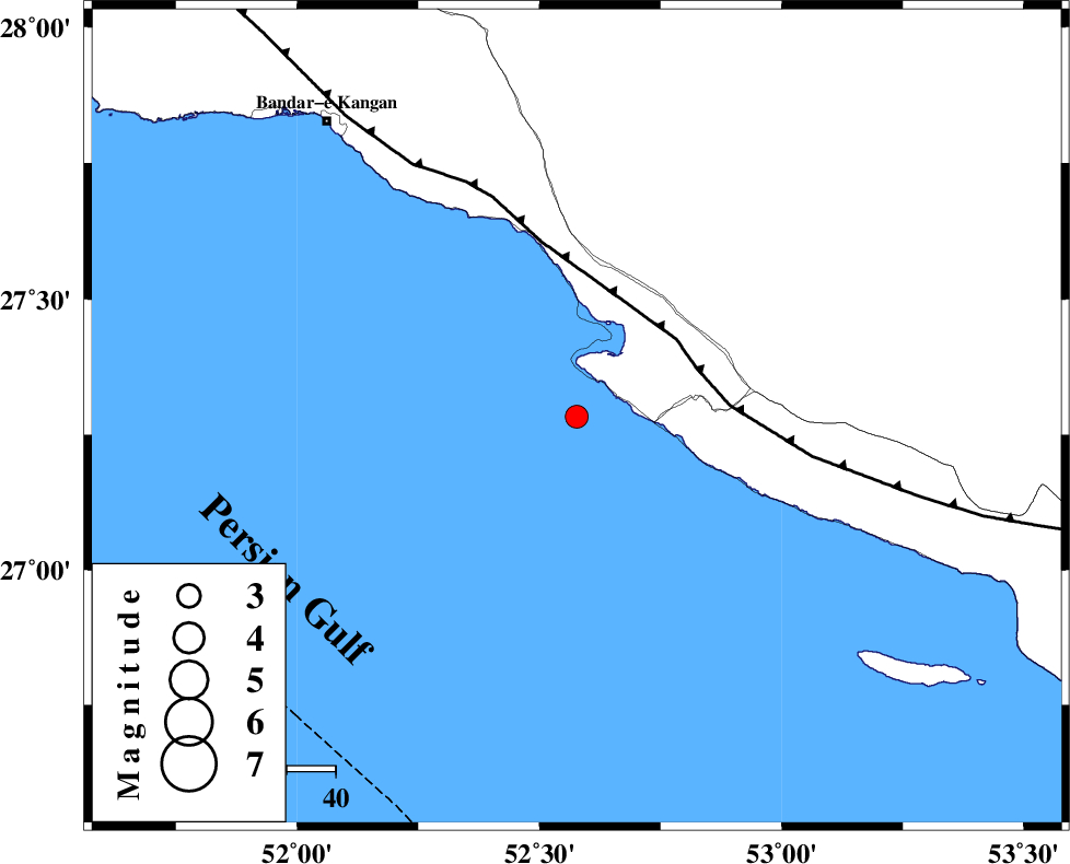
| Location | Lat:27.283 Lon: 52.577 |
| Region | Persian Gulf, 42 km South-West of Mehr |
Nearest Cities |
|
| 21 km South of Bandar-e asaluyeh, Bushehr Province | |
| 23 km West of Chah-e mobarak, Bushehr Province | |
| 41 km South West of Ardavan-e olia, Fars Province | |
| 42 km South West of Mehr, Fars Province | |
| 43 km South of Gallehdar, Fars Province | |
| Depth | 16 km |
| Agency | |
Faults within 150 km: |
|
| MFF3 (Length: 292 km) , Distance to epicenter: 26 km | |
| BORAZJAN_F (Length: 168 km) , Distance to epicenter: 125 km | |
| QIR_F (Length: 130 km) , Distance to epicenter: 130 km | |
| Number of Phases | 8 |
| RMS | 0.5 |
| Number of Stations | 8 |
| Error in Latitude | >5 km |
| Error in Longitude | 5 km |
| Error in Depth | 13.9 km |
Download waveform in seisan format
to download seisan software Click here
to access information about IIEES stations Click here
Amplitude | ||||||||
| UID | Agency | Station | Component | Amplitude | Period | Arrival Time | Proccessing Time | Signal Clip |
| 201310 | IIEES SC | UOSS | Z | 0.02 | 1 | 2026-02-01 12:03:25 | 2026-02-02 07:51:00 | n |
| 201311 | IIEES SC | IRSR | Z | 0.005 | 1 | 2026-02-01 12:04:12 | 2026-02-02 07:51:00 | n |
Phase | ||||||||||||
| Agency | Station | Component | Phase Type | Phase Quality | First Motion | Observed Arrival Time | Time Residual | Loc. Flag | Input Weight | Distance | Azimuth | |
| IIEES SC | GHIR | Z | EPg | E | 2026-02-01 12:02:42 | 0.2 | y | 0 | 118 | 20 | ||
| IIEES SC | ABH1 | Z | EPn | E | 2026-02-01 12:03:23 | -0.4 | y | 0 | 432 | 328 | ||
| IIEES SC | UOSS | Z | EPn | E | 2026-02-01 12:03:25 | 0.1 | y | 0 | 446 | 126 | ||
| IIEES SC | KRBR | Z | EPn | E | 2026-02-01 12:03:32 | -0.5 | y | 0 | 507 | 54 | ||
| IIEES SC | SFB | Z | EPn | E | 2026-02-01 12:04:08 | 0.9 | y | 0 | 784 | 358 | ||
| IIEES SC | CHBR | Z | EPn | E | 2026-02-01 12:04:02 | -8.6 | n | 4 | 810 | 103 | ||
| IIEES SC | IRSR | Z | EPn | E | 2026-02-01 12:04:12 | 0.4 | y | 0 | 822 | 92 | ||
| IIEES SC | SRSL | Z | EPn | E | 2026-02-01 12:04:58 | -0.7 | y | 0 | 1199 | 326 | ||