
Magnitude |
3.2 |
| Date & Time (UTC) | 2008-05-22 16:32:46.3 |
| Date & Time (Local) | 1387/3/2 21:02:46.3 |
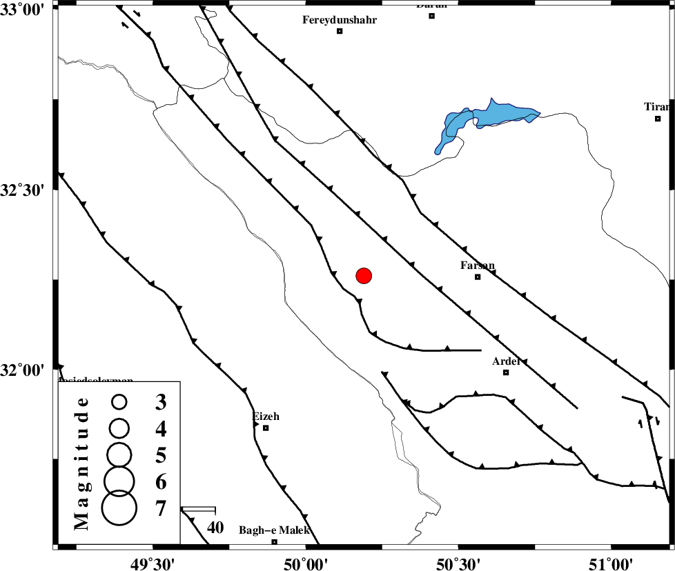
| Location | Lat:32.26 Lon: 50.19 |
| Region | 24 km South of Chelgard, Chaharmahal Bakhtiari Province |
Nearest Cities |
|
| 24 km South of Chelgard, Chaharmahal Bakhtiari Province | |
| 28 km West of Babaheydar, Chaharmahal Bakhtiari Province | |
| 34 km South of Kukanak, Esfahan Province | |
| 35 km North West of Farsan, Chaharmahal Bakhtiari Province | |
| 38 km South West of Haruni, Chaharmahal Bakhtiari Province | |
| Depth | 38 km |
| Agency | |
Faults within 150 km: |
|
| ZARDKUH_F (Length: 139 km) , Distance to epicenter: 7 km | |
| ARDAL_F (Length: 170 km) , Distance to epicenter: 18 km | |
| MAIN_ZAGROS_R_F (Length: 1106 km) , Distance to epicenter: 26 km | |
| Number of Phases | 5 |
| RMS | 0.4 |
| Number of Stations | 4 |
| Error in Latitude | >6.7 km |
| Error in Longitude | 10.3 km |
| Error in Depth | 13.4 km |
Download waveform in seisan format
to download seisan software Click here
to access information about IIEES stations Click here
Amplitude | ||||||||
| UID | Agency | Station | Component | Amplitude | Period | Arrival Time | Proccessing Time | Signal Clip |
| 49192 | IIEES | SHGR | N | 802.1 | 0.6 | 2008-05-22 16:33:30 | 2009-01-18 12:56:00 | n |
| 49193 | IIEES | SHGR | E | 606.1 | 0.44 | 2008-05-22 16:33:33 | 2009-01-18 12:56:00 | n |
| 49194 | IIEES | ASAO | E | 98.1 | 0.6 | 2008-05-22 16:34:05 | 2009-01-18 12:56:00 | n |
| 49195 | IIEES | ASAO | N | 112 | 0.6 | 2008-05-22 16:34:05 | 2009-01-18 12:56:00 | n |
| 49196 | IIEES | SNGE | N | 41.1 | 0.56 | 2008-05-22 16:34:32 | 2009-01-18 12:56:00 | n |
| 49197 | IIEES | SNGE | E | 26.5 | 0.6 | 2008-05-22 16:34:53 | 2009-01-18 12:56:00 | n |
Phase | ||||||||||||
| Agency | Station | Component | Phase Type | Phase Quality | First Motion | Observed Arrival Time | Time Residual | Loc. Flag | Input Weight | Distance | Azimuth | |
| IIEES | SHGR | Z | Pg | E | 2008-05-22 16:33:08 | 0.1 | y | 132 | 263 | |||
| IIEES | NASN | Z | Pn | E | 2008-05-22 16:33:23 | -0.2 | y | 253 | 76 | |||
| IIEES | ASAO | Z | Pn | E | 2008-05-22 16:33:24 | 0.6 | y | 255 | 357 | |||
| IIEES | ASAO | E | Sg | E | 2008-05-22 16:33:57 | -0.1 | y | 255 | 357 | |||
| IIEES | SNGE | Z | Pn | E | 2008-05-22 16:33:42 | -0.6 | y | 411 | 321 | |||