
Magnitude |
4 |
| Date & Time (UTC) | 2008-05-27 17:07:21.5 |
| Date & Time (Local) | 1387/3/7 21:37:21.5 |
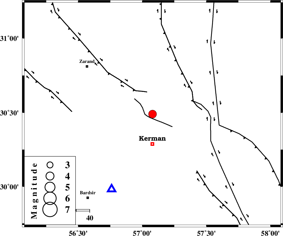
| Location | Lat:30.49 Lon: 57.08 |
| Region | 22 km North of Kerman, Kerman Province |
Nearest Cities |
|
| 17 km East of Hutak, Kerman Province | |
| 18 km North East of Zangiabad, Kerman Province | |
| 19 km West of Dehlulu, Kerman Province | |
| 19 km South of Harjand, Kerman Province | |
| 21 km South East of Chatrud, Kerman Province | |
| Depth | 14 km |
| Agency | |
Faults within 150 km: |
|
| CHATRUD_F (Length: 37 km) , Distance to epicenter: 3 km | |
| KUHBANAN_F (Length: 189 km) , Distance to epicenter: 17 km | |
| LAKARKUH_F (Length: 138 km) , Distance to epicenter: 32 km | |
| Number of Phases | 5 |
| RMS | 0.1 |
| Number of Stations | 4 |
| Error in Latitude | >3.7 km |
| Error in Longitude | 3.1 km |
| Error in Depth | 5.8 km |
Download waveform in seisan format
to download seisan software Click here
to access information about IIEES stations Click here
Amplitude | ||||||||
| UID | Agency | Station | Component | Amplitude | Period | Arrival Time | Proccessing Time | Signal Clip |
| 49259 | IIEES | KRBR | E | 9978.1 | 0.48 | 2008-05-27 17:07:44 | 2009-01-18 12:56:00 | n |
| 49260 | IIEES | KRBR | N | 7905.8 | 0.34 | 2008-05-27 17:07:50 | 2009-01-18 12:56:00 | n |
| 49261 | IIEES | BNDS | N | 296.2 | 0.54 | 2008-05-27 17:09:05 | 2009-01-18 12:56:00 | n |
| 49262 | IIEES | ZHSF | N | 362.5 | 0.56 | 2008-05-27 17:09:11 | 2009-01-18 12:56:00 | n |
Phase | ||||||||||||
| Agency | Station | Component | Phase Type | Phase Quality | First Motion | Observed Arrival Time | Time Residual | Loc. Flag | Input Weight | Distance | Azimuth | |
| IIEES | KRBR | Z | Pg | E | 2008-05-27 17:07:32 | -0.1 | y | 64.4 | 208 | |||
| IIEES | BNDS | Z | Pn | E | 2008-05-27 17:08:13 | 0.1 | y | 354 | 195 | |||
| IIEES | BNDS | N | Sg | E | 2008-05-27 17:09:00 | 0 | y | 354 | 195 | |||
| IIEES | ZHSF | Z | PN5 | E | 2008-05-27 17:08:15 | 0 | y | 370 | 104 | |||
| IIEES | GHIR | Z | Pn | E | 2008-05-27 17:08:27 | 0.1 | y | 466 | 239 | |||