
Magnitude |
2.9 |
| Date & Time (UTC) | 2009-04-04 22:34:26.3 |
| Date & Time (Local) | 1388/1/16 03:04:26.3 |
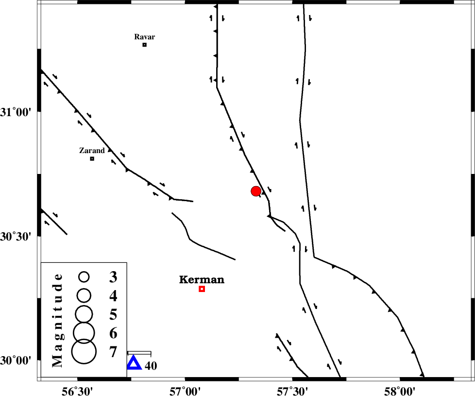
| Location | Lat:30.68 Lon: 57.33 |
| Region | 49 km North-East of Kerman, Kerman Province |
Nearest Cities |
|
| 19 km North East of Harjand, Kerman Province | |
| 20 km North of Dehlulu, Kerman Province | |
| 35 km East of Hejdak, Kerman Province | |
| 39 km North East of Hutak, Kerman Province | |
| 41 km North East of Chatrud, Kerman Province | |
| Depth | 18 km |
| Agency | |
Faults within 150 km: |
|
| LAKARKUH_F (Length: 138 km) , Distance to epicenter: 7 km | |
| GOLBAF_SIRCH_F (Length: 114 km) , Distance to epicenter: 13 km | |
| KUHBANAN_F (Length: 189 km) , Distance to epicenter: 28 km | |
| Number of Phases | 5 |
| RMS | 0.2 |
| Number of Stations | 3 |
| Error in Latitude | >3.2 km |
| Error in Longitude | 11.4 km |
| Error in Depth | 5.9 km |
Download waveform in seisan format
to download seisan software Click here
to access information about IIEES stations Click here
Amplitude | ||||||||
| UID | Agency | Station | Component | Amplitude | Period | Arrival Time | Proccessing Time | Signal Clip |
| 52365 | IIEES | TABS | N | 57.4 | 0.66 | 2009-04-04 22:36:04 | 2009-07-13 01:52:00 | n |
| 52366 | IIEES | TABS | E | 26.5 | 0.79 | 2009-04-04 22:36:05 | 2009-07-13 01:52:00 | n |
| 52367 | IIEES | NASN | E | 9.2 | 0.54 | 2009-04-04 22:36:36 | 2009-07-13 01:52:00 | n |
Phase | ||||||||||||
| Agency | Station | Component | Phase Type | Phase Quality | First Motion | Observed Arrival Time | Time Residual | Loc. Flag | Input Weight | Distance | Azimuth | |
| IIEES | KRBR | Z | Pg | E | 2009-04-04 22:34:42 | 0.1 | y | 94.3 | 215 | |||
| IIEES | KRBR | N | Sg | E | 2009-04-04 22:34:54 | 0 | y | 94.3 | 215 | |||
| IIEES | TABS | Z | Pn | E | 2009-04-04 22:35:14 | -0.2 | y | 330 | 357 | |||
| IIEES | TABS | N | Sg | E | 2009-04-04 22:35:58 | 0.2 | y | 330 | 357 | |||
| IIEES | NASN | Z | Pn | E | 2009-04-04 22:35:34 | -0.2 | y | 488 | 300 | |||