
Magnitude |
2.8 |
| Date & Time (UTC) | 2011-10-26 17:09:54.6 |
| Date & Time (Local) | 1390/8/4 20:39:54.6 |
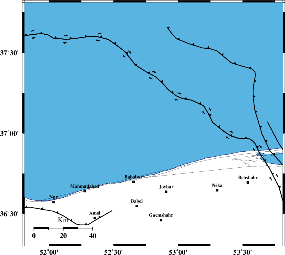
| Location | Lat:37.06 Lon: 52.81 |
| Region | Caspian Sea, 43 km North-East of Babolsar |
Nearest Cities |
|
| 39 km North West of Larim, Mazandaran Province | |
| 40 km North West of Farahabad, Mazandaran Province | |
| 43 km North East of Babolsar, Mazandaran Province | |
| 43 km North of Bahmonir, Mazandaran Province | |
| 44 km North West of Kuhikhel, Mazandaran Province | |
| Depth | 17 km |
| Agency | |
Faults within 150 km: |
|
| KHAZAR_F (Length: 523 km) , Distance to epicenter: 64 km | |
| N_ALBORZ_F (Length: 360 km) , Distance to epicenter: 97 km | |
| KOJOOR (Length: 75 km) , Distance to epicenter: 125 km | |
| Number of Phases | 8 |
| RMS | 0.1 |
| Number of Stations | 5 |
| Error in Latitude | >3.9 km |
| Error in Longitude | 1.3 km |
| Error in Depth | 3.8 km |
Download waveform in seisan format
to download seisan software Click here
to access information about IIEES stations Click here
Amplitude | ||||||||
| UID | Agency | Station | Component | Amplitude | Period | Arrival Time | Proccessing Time | Signal Clip |
| 80536 | IIEES | THKV | E | 78.3 | 0.52 | 2011-10-26 17:11:06 | 2011-10-26 11:43:00 | n |
Phase | ||||||||||||
| Agency | Station | Component | Phase Type | Phase Quality | First Motion | Observed Arrival Time | Time Residual | Loc. Flag | Input Weight | Distance | Azimuth | |
| IIEES | CHTH | Z | Pn | E | 2011-10-26 17:10:26 | -0.08 | y | 198 | 230 | |||
| IIEES | CHTH | N | Sg | E | 2011-10-26 17:10:51 | -0.06 | y | 198 | 230 | |||
| IIEES | THKV | Z | Pn | E | 2011-10-26 17:10:28 | -0.06 | y | 214 | 234 | |||
| IIEES | THKV | E | Sg | E | 2011-10-26 17:10:55 | 0.09 | y | 214 | 234 | |||
| IIEES | MRVT | Z | Pn | E | 2011-10-26 17:10:39 | 0.03 | y | 298 | 76 | |||
| IIEES | SHRO | Z | Pn | E | 2011-10-26 17:10:40 | 0.03 | y | 310 | 111 | |||
| IIEES | SHRO | E | Sg | E | 2011-10-26 17:11:21 | -0.03 | y | 310 | 111 | |||
| IIEES | GHVR | Z | Pn | E | 2011-10-26 17:10:41 | 0.1 | y | 319 | 207 | |||