
Magnitude |
2.9 |
| Date & Time (UTC) | 2012-12-08 16:28:08.3 |
| Date & Time (Local) | 1391/9/18 19:58:08.3 |
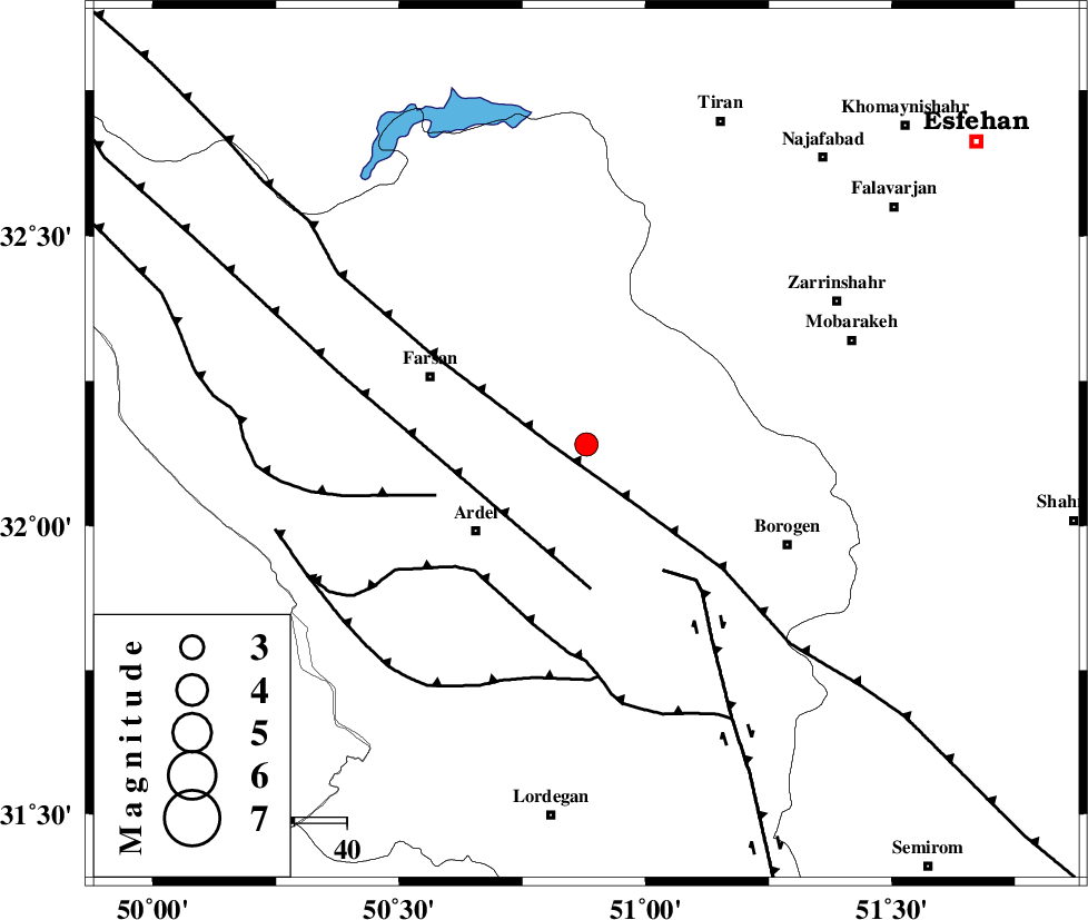
| Location | Lat:32.14 Lon: 50.88 |
| Region | Chaharmahal Bakhtiari Province, 22 km South of Shahr-e kord |
Nearest Cities |
|
| 12 km of Hafshjan, Chaharmahal Bakhtiari Province | |
| 13 km North of Shalamzar, Chaharmahal Bakhtiari Province | |
| 18 km East of Jonqan, Chaharmahal Bakhtiari Province | |
| 21 km South of Shahr-e kord, Chaharmahal Bakhtiari Province | |
| 26 km North East of Naghan, Chaharmahal Bakhtiari Province | |
| Depth | 16 km |
| Agency | |
Faults within 150 km: |
|
| MAIN_ZAGROS_R_F (Length: 1106 km) , Distance to epicenter: 7 km | |
| ARDAL_F (Length: 170 km) , Distance to epicenter: 28 km | |
| DENA_F (Length: 137 km) , Distance to epicenter: 28 km | |
| Number of Phases | 5 |
| RMS | 0.1 |
| Number of Stations | 4 |
| Error in Latitude | >2.7 km |
| Error in Longitude | 2.7 km |
| Error in Depth | 6 km |
Download waveform in seisan format
to download seisan software Click here
to access information about IIEES stations Click here
Amplitude | ||||||||
| UID | Agency | Station | Component | Amplitude | Period | Arrival Time | Proccessing Time | Signal Clip |
| 87291 | IIEES | SHGR | E | 110.4 | 0.64 | 2012-12-08 16:29:19 | 2012-12-08 04:56:00 | n |
| 87292 | IIEES | SHGR | N | 106.7 | 0.52 | 2012-12-08 16:29:19 | 2012-12-08 04:56:00 | n |
Phase | ||||||||||||
| Agency | Station | Component | Phase Type | Phase Quality | First Motion | Observed Arrival Time | Time Residual | Loc. Flag | Input Weight | Distance | Azimuth | |
| IIEES | SHGR | Z | Pg | E | 2012-12-08 16:28:40 | 0.1 | y | 196 | 270 | |||
| IIEES | SHGR | E | Sg | E | 2012-12-08 16:29:03 | -0.07 | y | 196 | 270 | |||
| IIEES | KHMZ | Z | Pg | E | 2012-12-08 16:28:40 | -0.03 | y | 197 | 335 | |||
| IIEES | GHVR | Z | Pn | E | 2012-12-08 16:28:48 | 0.04 | y | 262 | 7 | |||
| IIEES | YZKH | Z | Pn | E | 2012-12-08 16:28:59 | -0.05 | y | 351 | 84 | |||