
Magnitude |
3.5 |
| Date & Time (UTC) | 2013-01-14 02:26:29.8 |
| Date & Time (Local) | 1391/10/25 05:56:29.8 |
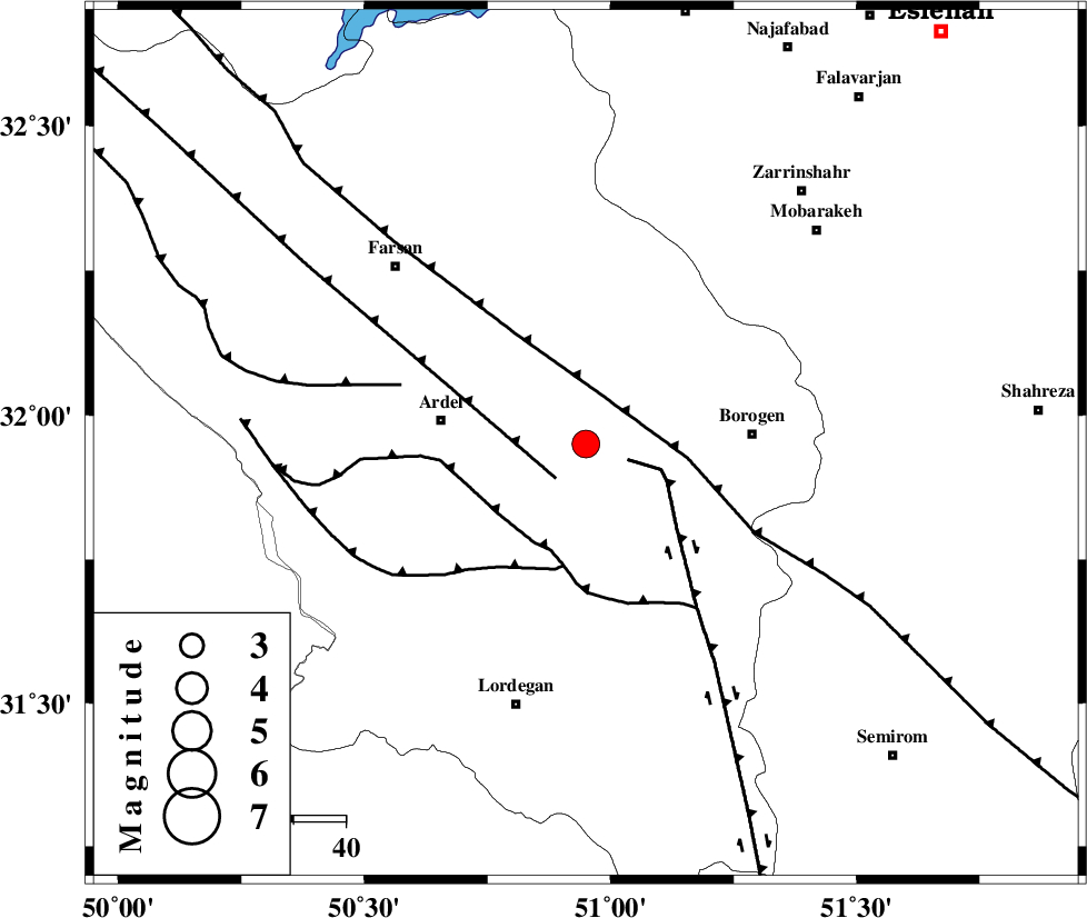
| Location | Lat:31.95 Lon: 50.95 |
| Region | Chaharmahal Bakhtiari Province, 28 km East of Ardel |
Nearest Cities |
|
| 10 km North of Baladaji, Chaharmahal Bakhtiari Province | |
| 17 km East of Shalamzar, Chaharmahal Bakhtiari Province | |
| 20 km North East of Naghan, Chaharmahal Bakhtiari Province | |
| 22 km North West of Gandoman, Chaharmahal Bakhtiari Province | |
| 24 km West of Faradonbeh, Chaharmahal Bakhtiari Province | |
| Depth | 18 km |
| Agency | |
Faults within 150 km: |
|
| DENA_F (Length: 137 km) , Distance to epicenter: 9 km | |
| ARDAL_F (Length: 170 km) , Distance to epicenter: 9 km | |
| MAIN_ZAGROS_R_F (Length: 1106 km) , Distance to epicenter: 11 km | |
| Number of Phases | 7 |
| RMS | 0.1 |
| Number of Stations | 5 |
| Error in Latitude | >1.5 km |
| Error in Longitude | 1.9 km |
| Error in Depth | 4.4 km |
Download waveform in seisan format
to download seisan software Click here
to access information about IIEES stations Click here
Amplitude | ||||||||
| UID | Agency | Station | Component | Amplitude | Period | Arrival Time | Proccessing Time | Signal Clip |
| 87615 | IIEES | SHGR | N | 420.6 | 0.52 | 2013-01-14 02:27:47 | 2013-01-14 02:57:00 | n |
Phase | ||||||||||||
| Agency | Station | Component | Phase Type | Phase Quality | First Motion | Observed Arrival Time | Time Residual | Loc. Flag | Input Weight | Distance | Azimuth | |
| IIEES | SHGR | Z | P | E | 2013-01-14 02:27:02 | -0.12 | y | 204 | 276 | |||
| IIEES | SHGR | E | Sg | E | 2013-01-14 02:27:27 | 0.07 | y | 204 | 276 | |||
| IIEES | KHMZ | Z | Pn | E | 2013-01-14 02:27:04 | -0.13 | y | 219 | 335 | |||
| IIEES | KHMZ | E | Sg | E | 2013-01-14 02:27:32 | 0.03 | y | 219 | 335 | |||
| IIEES | AHRM | Z | Pn | E | 2013-01-14 02:27:19 | 0.06 | y | 343 | 174 | |||
| IIEES | YZKH | Z | Pn | E | 2013-01-14 02:27:20 | 0.11 | y | 347 | 81 | |||
| IIEES | SNGE | Z | Pn | E | 2013-01-14 02:27:37 | -0.01 | y | 483 | 317 | |||