
Magnitude |
2.4 |
| Date & Time (UTC) | 2013-02-02 23:20:26.5 |
| Date & Time (Local) | 1391/11/15 02:50:26.5 |
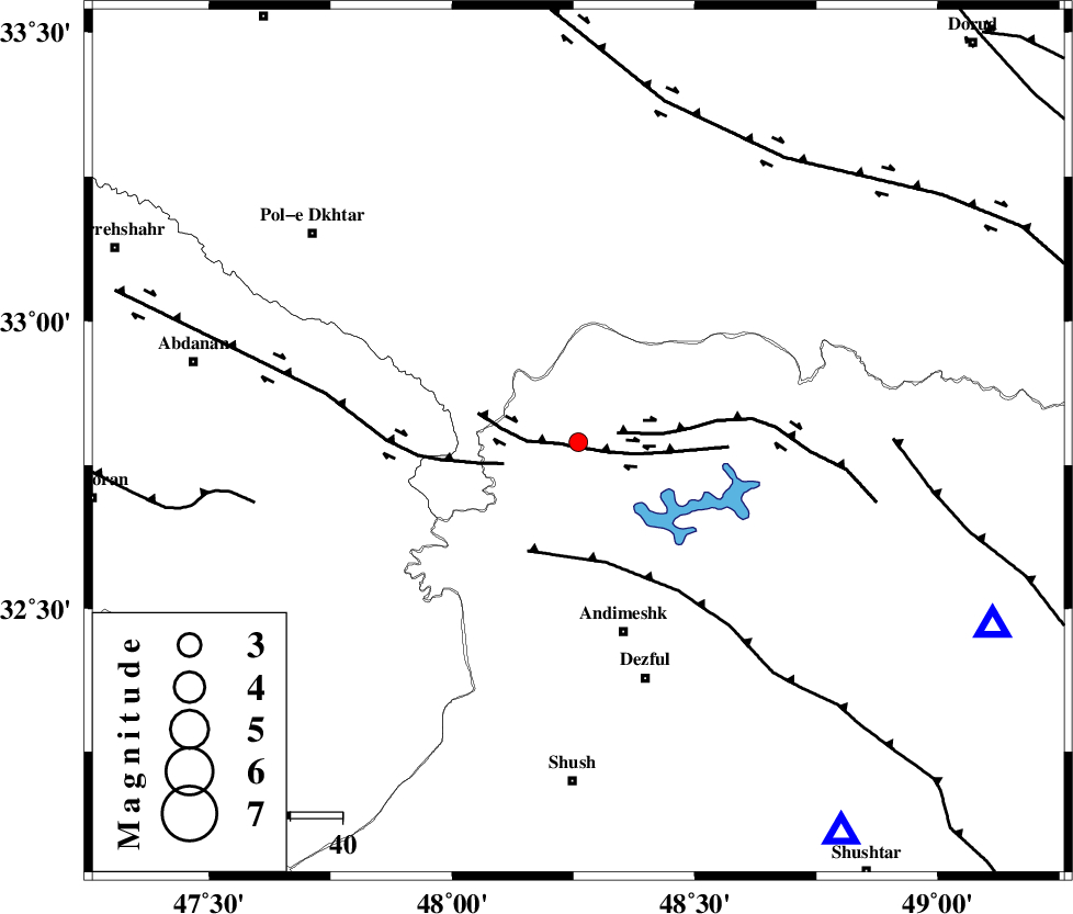
| Location | Lat:32.79 Lon: 48.26 |
| Region | Khoozestan Province, 38 km North of Andimeshk |
Nearest Cities |
|
| 4 km North of Bidruyeh, Khoozestan Province | |
| 7 km North of Sorkhakan, Khoozestan Province | |
| 12 km North of Hoseinieh, Khoozestan Province | |
| 38 km North of Andimeshk, Khoozestan Province | |
| 47 km North West of Dezful, Khoozestan Province | |
| Depth | 14 km |
| Agency | |
Faults within 150 km: |
|
| BALARUD_F_Z3 (Length: 53 km) , Distance to epicenter: 1 km | |
| BALARUD_F_Z2 (Length: 58 km) , Distance to epicenter: 8 km | |
| BALARUD_F_Z1 (Length: 87 km) , Distance to epicenter: 15 km | |
| Number of Phases | 5 |
| RMS | 0 |
| Number of Stations | 4 |
| Error in Latitude | >1.9 km |
| Error in Longitude | 3.6 km |
| Error in Depth | 5.7 km |
Download waveform in seisan format
to download seisan software Click here
to access information about IIEES stations Click here
Amplitude | ||||||||
| UID | Agency | Station | Component | Amplitude | Period | Arrival Time | Proccessing Time | Signal Clip |
| 87790 | IIEES | SHGR | E | 133.1 | 0.52 | 2013-02-02 23:21:00 | 2013-02-03 03:15:00 | n |
| 87791 | IIEES | SHGR | N | 116.3 | 0.4 | 2013-02-02 23:21:05 | 2013-02-03 03:15:00 | n |
| 87792 | IIEES | SNGE | N | 20.1 | 0.8 | 2013-02-02 23:21:52 | 2013-02-03 03:15:00 | n |
Phase | ||||||||||||
| Agency | Station | Component | Phase Type | Phase Quality | First Motion | Observed Arrival Time | Time Residual | Loc. Flag | Input Weight | Distance | Azimuth | |
| IIEES | SHGR | Z | Pg | E | 2013-02-02 23:20:41 | 0 | y | 90.9 | 146 | |||
| IIEES | KHMZ | Z | Pg | E | 2013-02-02 23:20:57 | 0 | y | 190 | 56 | |||
| IIEES | KHMZ | N | Sg | E | 2013-02-02 23:21:20 | 0 | y | 190 | 56 | |||
| IIEES | ASAO | Z | Pn | E | 2013-02-02 23:21:05 | 0.01 | y | 254 | 39 | |||
| IIEES | SNGE | Z | Pn | E | 2013-02-02 23:21:07 | -0.01 | y | 269 | 342 | |||