
Magnitude |
3.5 |
| Date & Time (UTC) | 2013-02-25 01:58:56.7 |
| Date & Time (Local) | 1391/12/7 05:28:56.7 |
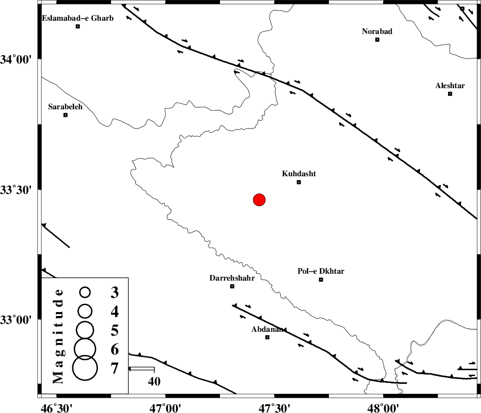
| Location | Lat:33.46 Lon: 47.43 |
| Region | Lorestan Province, 18 km West of Kuhdasht |
Nearest Cities |
|
| 6 km of Ashtarheh golgol, Lorestan Province | |
| 11 km North of Kunani, Lorestan Province | |
| 15 km North of Suri, Lorestan Province | |
| 17 km East of Garab, Lorestan Province | |
| 18 km West of Kuhdasht, Lorestan Province | |
| Depth | 17 km |
| Agency | |
Faults within 150 km: |
|
| BALARUD_F_Z1 (Length: 87 km) , Distance to epicenter: 47 km | |
| HZF4 (Length: 492 km) , Distance to epicenter: 50 km | |
| MFF6 (Length: 144 km) , Distance to epicenter: 81 km | |
| Number of Phases | 6 |
| RMS | 0.1 |
| Number of Stations | 5 |
| Error in Latitude | >2.1 km |
| Error in Longitude | 5.1 km |
| Error in Depth | 3.3 km |
Download waveform in seisan format
to download seisan software Click here
to access information about IIEES stations Click here
Amplitude | ||||||||
| UID | Agency | Station | Component | Amplitude | Period | Arrival Time | Proccessing Time | Signal Clip |
| 88020 | IIEES | SNGE | N | 855.2 | 0.4 | 2013-02-25 01:59:54 | 2013-02-25 02:34:00 | n |
| 88021 | IIEES | SNGE | E | 555.3 | 0.6 | 2013-02-25 01:59:57 | 2013-02-25 02:34:00 | n |
| 88022 | IIEES | SHGR | N | 442.3 | 0.24 | 2013-02-25 01:59:54 | 2013-02-25 02:34:00 | n |
| 88023 | IIEES | SHGR | E | 395.1 | 0.56 | 2013-02-25 02:00:06 | 2013-02-25 02:34:00 | n |
Phase | ||||||||||||
| Agency | Station | Component | Phase Type | Phase Quality | First Motion | Observed Arrival Time | Time Residual | Loc. Flag | Input Weight | Distance | Azimuth | |
| IIEES | SNGE | Z | Pg | E | 2013-02-25 01:59:26 | -0.01 | y | 182 | 357 | |||
| IIEES | SHGR | Z | Pn | E | 2013-02-25 01:59:28 | 0.01 | y | 197 | 139 | |||
| IIEES | SHGR | E | Sg | E | 2013-02-25 01:59:52 | 0.01 | y | 197 | 139 | |||
| IIEES | KHMZ | Z | Pn | E | 2013-02-25 01:59:33 | -0.15 | y | 237 | 82 | |||
| IIEES | ASAO | Z | Pn | E | 2013-02-25 01:59:37 | 0.07 | y | 268 | 62 | |||
| IIEES | GHVR | Z | Pn | E | 2013-02-25 01:59:50 | 0.1 | y | 370 | 71 | |||