
Magnitude |
2.5 |
| Date & Time (UTC) | 2013-04-23 04:34:55.3 |
| Date & Time (Local) | 1392/2/3 09:04:55.3 |
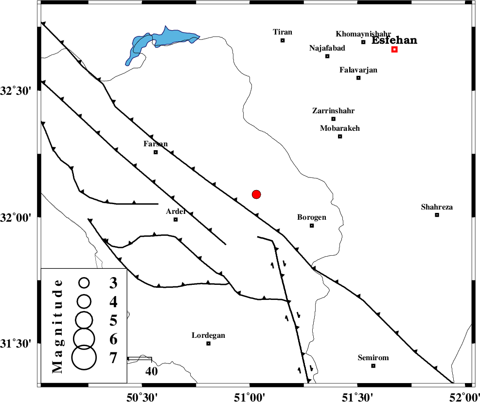
| Location | Lat:32.09 Lon: 51.03 |
| Region | Chaharmahal Bakhtiari Province, 28 km North-West of Borujen |
Nearest Cities |
|
| 14 km West of Sefid-dasht, Chaharmahal Bakhtiari Province | |
| 18 km North of Baladaji, Chaharmahal Bakhtiari Province | |
| 18 km North West of Faradonbeh, Chaharmahal Bakhtiari Province | |
| 22 km North East of Shalamzar, Chaharmahal Bakhtiari Province | |
| 27 km South East of Hafshjan, Chaharmahal Bakhtiari Province | |
| Depth | 18 km |
| Agency | |
Faults within 150 km: |
|
| MAIN_ZAGROS_R_F (Length: 1106 km) , Distance to epicenter: 8 km | |
| DENA_F (Length: 137 km) , Distance to epicenter: 19 km | |
| ARDAL_F (Length: 170 km) , Distance to epicenter: 26 km | |
| Number of Phases | 5 |
| RMS | 0 |
| Number of Stations | 4 |
| Error in Latitude | >8 km |
| Error in Longitude | 5.9 km |
| Error in Depth | 9.8 km |
Download waveform in seisan format
to download seisan software Click here
to access information about IIEES stations Click here
Amplitude | ||||||||
| UID | Agency | Station | Component | Amplitude | Period | Arrival Time | Proccessing Time | Signal Clip |
| 88910 | IIEES | KHMZ | N | 41.3 | 0.62 | 2013-04-23 04:36:04 | 2013-04-23 10:07:00 | n |
| 88911 | IIEES | KHMZ | E | 39 | 0.44 | 2013-04-23 04:36:07 | 2013-04-23 10:07:00 | n |
| 88912 | IIEES | GHVR | E | 26.2 | 0.49 | 2013-04-23 04:36:23 | 2013-04-23 10:07:00 | n |
| 88913 | IIEES | GHVR | N | 26 | 0.41 | 2013-04-23 04:36:23 | 2013-04-23 10:07:00 | n |
| 88914 | IIEES | ASAO | E | 22.2 | 0.58 | 2013-04-23 04:36:28 | 2013-04-23 10:07:00 | n |
| 88915 | IIEES | YZKH | N | 10 | 0.39 | 2013-04-23 04:36:39 | 2013-04-23 10:07:00 | n |
Phase | ||||||||||||
| Agency | Station | Component | Phase Type | Phase Quality | First Motion | Observed Arrival Time | Time Residual | Loc. Flag | Input Weight | Distance | Azimuth | |
| IIEES | KHMZ | Z | Pn | E | 2013-04-23 04:35:28 | 0.01 | y | 208 | 332 | |||
| IIEES | GHVR | Z | Pn | E | 2013-04-23 04:35:35 | -0.05 | y | 266 | 4 | |||
| IIEES | ASAO | Z | Pn | E | 2013-04-23 04:35:38 | 0.01 | y | 288 | 341 | |||
| IIEES | ASAO | E | Sg | E | 2013-04-23 04:36:16 | 0.02 | y | 288 | 341 | |||
| IIEES | YZKH | Z | Pn | E | 2013-04-23 04:35:44 | 0.02 | y | 338 | 83 | |||