
Magnitude |
3.2 |
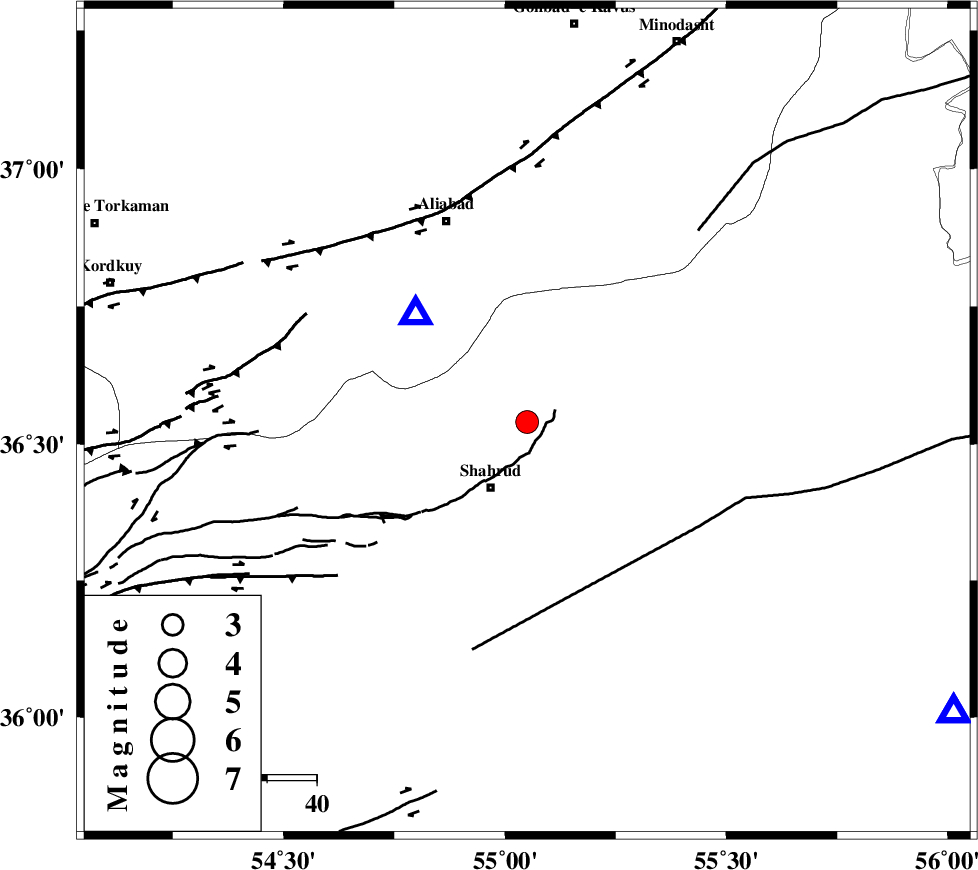
| Date & Time (UTC) | 2013-05-09 21:10:06.3 |
| Date & Time (Local) | 1392/2/20 01:40:06.3 |
| Location | Lat:36.54 Lon: 55.05 |
| Region | Semnan Province, 15 km North of Shahrud |
Nearest Cities |
|
| 8 km North of Bastam, Semnan Province | |
| 12 km of Qaleh-ye nokharqan, Semnan Province | |
| 15 km North of Shahrud, Semnan Province | |
| 22 km North of Ruyan, Semnan Province | |
| 27 km South West of Kalateh khanj, Semnan Province | |
| Depth | 14 km |
| Agency | |
Faults within 150 km: |
|
| SHAVAR_F (Length: 87 km) , Distance to epicenter: 13 km | |
| DAMGHAN_F (Length: 95 km) , Distance to epicenter: 38 km | |
| ASTANEH_F (Length: 72 km) , Distance to epicenter: 40 km | |
| Number of Phases | 7 |
| RMS | 0.2 |
| Number of Stations | 6 |
| Error in Latitude | >2.2 km |
| Error in Longitude | 4 km |
| Error in Depth | 7.5 km |
Download waveform in seisan format
to download seisan software Click here
to access information about IIEES stations Click here
Amplitude | ||||||||
| UID | Agency | Station | Component | Amplitude | Period | Arrival Time | Proccessing Time | Signal Clip |
| 89128 | IIEES | GHVR | E | 39.2 | 0.48 | 2013-05-09 21:12:11 | 2013-05-10 12:08:00 | n |
Phase | ||||||||||||
| Agency | Station | Component | Phase Type | Phase Quality | First Motion | Observed Arrival Time | Time Residual | Loc. Flag | Input Weight | Distance | Azimuth | |
| IIEES | SHRO | Z | Pg | E | 2013-05-09 21:10:23 | -0.24 | y | 105 | 124 | |||
| IIEES | SHRO | E | Sg | E | 2013-05-09 21:10:37 | 0 | y | 105 | 124 | |||
| IIEES | BJRD | N | Pn | E | 2013-05-09 21:10:45 | 0.32 | y | 246 | 58 | |||
| IIEES | BJRD | E | Sg | E | 2013-05-09 21:11:15 | -0.13 | y | 246 | 58 | |||
| IIEES | CHTH | Z | Pn | E | 2013-05-09 21:10:58 | -0.23 | y | 359 | 260 | |||
| IIEES | TABS | Z | Pn | E | 2013-05-09 21:11:00 | 0.12 | y | 372 | 149 | |||
| IIEES | YZKH | Z | Pn | E | 2013-05-09 21:11:11 | 0.22 | y | 462 | 185 | |||