
Magnitude |
2.3 |
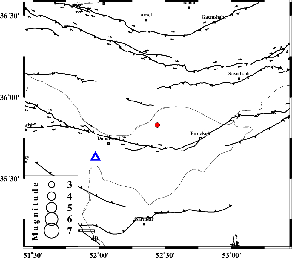
| Date & Time (UTC) | 2013-06-21 22:04:59.7 |
| Date & Time (Local) | 1392/4/1 02:34:59.7 |
| Location | Lat:35.83 Lon: 52.44 |
| Region | Tehran Province, 31 km West of Firuzkuh |
Nearest Cities |
|
| 8 km North of Arjomand, Tehran Province | |
| 21 km South East of Baijan, Mazandaran Province | |
| 23 km North West of Shahrabad, Tehran Province | |
| 24 km East of Gaznak, Mazandaran Province | |
| 24 km North East of Sarbandan, Tehran Province | |
| Depth | 13 km |
| Agency | |
Faults within 150 km: |
|
| MOSHA_F (Length: 234 km) , Distance to epicenter: 15 km | |
| N_ALBORZ_F (Length: 360 km) , Distance to epicenter: 42 km | |
| ATARI_F (Length: 185 km) , Distance to epicenter: 49 km | |
| Number of Phases | 4 |
| RMS | 0 |
| Number of Stations | 3 |
| Error in Latitude | >3.1 km |
| Error in Longitude | 7.6 km |
| Error in Depth | 7.2 km |
Download waveform in seisan format
to download seisan software Click here
to access information about IIEES stations Click here
Amplitude | ||||||||
| UID | Agency | Station | Component | Amplitude | Period | Arrival Time | Proccessing Time | Signal Clip |
| 89707 | IIEES | DAMV | E | 186 | 0.16 | 2013-06-21 22:05:16 | 2013-06-22 03:22:00 | n |
| 89708 | IIEES | GHVR | E | 39.9 | 0.32 | 2013-06-21 22:06:02 | 2013-06-22 03:22:00 | n |
Phase | ||||||||||||
| Agency | Station | Component | Phase Type | Phase Quality | First Motion | Observed Arrival Time | Time Residual | Loc. Flag | Input Weight | Distance | Azimuth | |
| IIEES | DAMV | Z | Pg | E | 2013-06-21 22:05:08 | 0 | y | 48.1 | 242 | |||
| IIEES | DAMV | E | Sg | E | 2013-06-21 22:05:15 | 0 | y | 48.1 | 242 | |||
| IIEES | CHTH | Z | Pg | E | 2013-06-21 22:05:20 | 0 | y | 119 | 274 | |||
| IIEES | GHVR | Z | P | E | 2013-06-21 22:05:29 | 0 | y | 185 | 216 | |||