
Magnitude |
2.3 |
| Date & Time (UTC) | 2013-08-10 16:50:09.4 |
| Date & Time (Local) | 1392/5/19 21:20:09.4 |
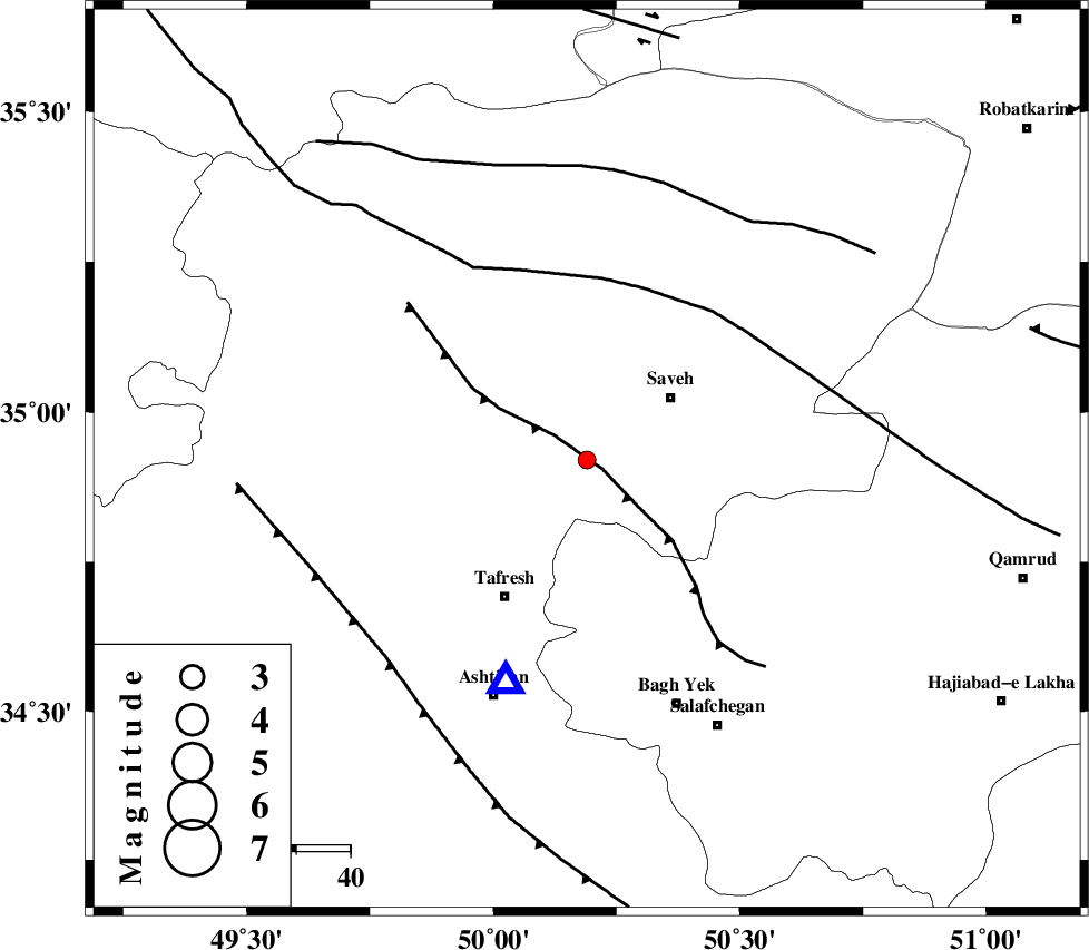
| Location | Lat:34.92 Lon: 50.19 |
| Region | Markazi Province, 20 km South-West of Saveh |
Nearest Cities |
|
| 11 km West of Yalabad, Markazi Province | |
| 13 km North East of Khanak, Markazi Province | |
| 17 km North West of Qareh chay, Markazi Province | |
| 19 km South West of Saveh, Markazi Province | |
| 21 km South East of Qeytaniyeh, Markazi Province | |
| Depth | 20 km |
| Agency | |
Faults within 150 km: |
|
| INDES_F (Length: 98 km) , Distance to epicenter: 3 km | |
| KUSHK_E_NOSRAT_F (Length: 230 km) , Distance to epicenter: 34 km | |
| TAFRESH_F (Length: 117 km) , Distance to epicenter: 52 km | |
| Number of Phases | 6 |
| RMS | 0.2 |
| Number of Stations | 3 |
| Error in Latitude | >4.1 km |
| Error in Longitude | 3.2 km |
| Error in Depth | 10.3 km |
Download waveform in seisan format
to download seisan software Click here
to access information about IIEES stations Click here
Amplitude | ||||||||
| UID | Agency | Station | Component | Amplitude | Period | Arrival Time | Proccessing Time | Signal Clip |
| 90193 | IIEES | GHVR | N | 54 | 0.12 | 2013-08-10 16:50:41 | 2013-08-10 06:44:00 | n |
| 90194 | IIEES | GHVR | E | 58.9 | 0.44 | 2013-08-10 16:50:42 | 2013-08-10 06:44:00 | n |
| 90195 | IIEES | KHMZ | E | 82.3 | 0.24 | 2013-08-10 16:50:49 | 2013-08-10 06:44:00 | n |
| 90196 | IIEES | KHMZ | N | 59.2 | 0.44 | 2013-08-10 16:50:49 | 2013-08-10 06:44:00 | n |
Phase | ||||||||||||
| Agency | Station | Component | Phase Type | Phase Quality | First Motion | Observed Arrival Time | Time Residual | Loc. Flag | Input Weight | Distance | Azimuth | |
| IIEES | ASAO | Z | Pg | E | 2013-08-10 16:50:17 | 0.28 | y | 43.5 | 200 | |||
| IIEES | ASAO | E | Sg | E | 2013-08-10 16:50:23 | -0.16 | y | 43.5 | 200 | |||
| IIEES | GHVR | Z | Pg | E | 2013-08-10 16:50:27 | -0.11 | y | 109 | 116 | |||
| IIEES | GHVR | N | Sg | E | 2013-08-10 16:50:40 | 0.06 | y | 109 | 116 | |||
| IIEES | KHMZ | Z | Pg | E | 2013-08-10 16:50:31 | -0.17 | y | 132 | 189 | |||
| IIEES | KHMZ | E | Sg | E | 2013-08-10 16:50:47 | 0.1 | y | 132 | 189 | |||