
Magnitude |
4.3 |
| Date & Time (UTC) | 2013-09-23 01:41:36.7 |
| Date & Time (Local) | 1392/7/1 05:11:36.7 |
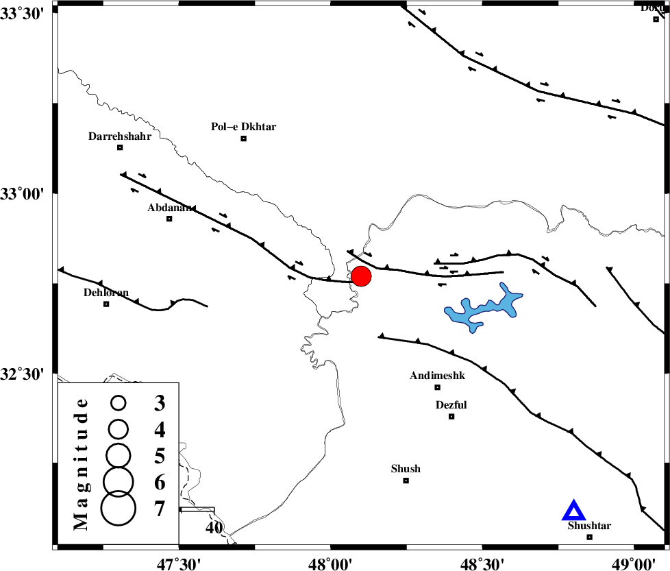
| Location | Lat:32.77 Lon: 48.1 |
| Region | Khoozestan Province, 42 km North-West of Andimeshk |
Nearest Cities |
|
| 13 km North West of Bidruyeh, Khoozestan Province | |
| 17 km North West of Hoseinieh, Khoozestan Province | |
| 21 km West of Sorkhakan, Khoozestan Province | |
| 42 km North West of Andimeshk, Khoozestan Province | |
| 52 km North West of Dezful, Khoozestan Province | |
| Depth | 15 km |
| Agency | |
Faults within 150 km: |
|
| BALARUD_F_Z1 (Length: 87 km) , Distance to epicenter: 2 km | |
| BALARUD_F_Z3 (Length: 53 km) , Distance to epicenter: 5 km | |
| DEZFUL_EMBAYMENT (Length: 228 km) , Distance to epicenter: 19 km | |
| Number of Phases | 6 |
| RMS | 0.1 |
| Number of Stations | 5 |
| Error in Latitude | >1.5 km |
| Error in Longitude | 3.5 km |
| Error in Depth | 4.5 km |
Download waveform in seisan format
to download seisan software Click here
to access information about IIEES stations Click here
Amplitude | ||||||||
| UID | Agency | Station | Component | Amplitude | Period | Arrival Time | Proccessing Time | Signal Clip |
| 90606 | IIEES | SHGR | N | 9016 | 0.68 | 2013-09-23 01:42:23 | 2013-09-23 03:06:00 | n |
| 90607 | IIEES | SHGR | E | 8334.3 | 0.52 | 2013-09-23 01:42:27 | 2013-09-23 03:06:00 | n |
Phase | ||||||||||||
| Agency | Station | Component | Phase Type | Phase Quality | First Motion | Observed Arrival Time | Time Residual | Loc. Flag | Input Weight | Distance | Azimuth | |
| IIEES | SHGR | Z | Pg | E | 2013-09-23 01:41:53 | 0 | y | 98.8 | 138 | |||
| IIEES | ASAO | E | Sg | E | 2013-09-23 01:42:51 | 0 | y | 266 | 42 | |||
| IIEES | SNGE | Z | Pn | E | 2013-09-23 01:42:17 | -0.03 | y | 266 | 345 | |||
| IIEES | ASAO | Z | Pn | E | 2013-09-23 01:42:17 | -0.11 | y | 266 | 42 | |||
| IIEES | GHVR | Z | Pn | E | 2013-09-23 01:42:27 | 0.08 | y | 348 | 56 | |||
| IIEES | ZNJK | Z | Pn | E | 2013-09-23 01:42:38 | 0.09 | y | 436 | 7 | |||