
Magnitude |
3.3 |
| Date & Time (UTC) | 2013-10-15 17:28:10.8 |
| Date & Time (Local) | 1392/7/23 20:58:10.8 |
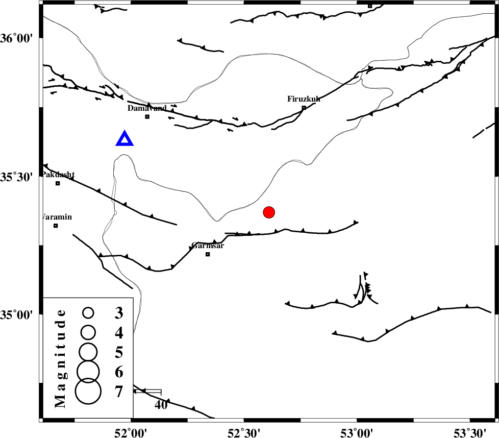
| Location | Lat:35.37 Lon: 52.61 |
| Region | Semnan Province, 30 km North-East of Garmsar |
Nearest Cities |
|
| 16 km North of Aradan, Semnan Province | |
| 17 km North of Kohanabad, Semnan Province | |
| 21 km North East of Davarabad, Semnan Province | |
| 23 km South of Atashan, Tehran Province | |
| 28 km North East of Gardovan, Semnan Province | |
| Depth | 16 km |
| Agency | |
Faults within 150 km: |
|
| GARMSAR_F (Length: 77 km) , Distance to epicenter: 9 km | |
| KUH_E_GACHAB_F1 (Length: 53 km) , Distance to epicenter: 34 km | |
| MOSHA_F (Length: 234 km) , Distance to epicenter: 36 km | |
| Number of Phases | 5 |
| RMS | 0.1 |
| Number of Stations | 5 |
| Error in Latitude | >3.3 km |
| Error in Longitude | 3.1 km |
| Error in Depth | 5.1 km |
Download waveform in seisan format
to download seisan software Click here
to access information about IIEES stations Click here
Amplitude | ||||||||
| UID | Agency | Station | Component | Amplitude | Period | Arrival Time | Proccessing Time | Signal Clip |
| 90796 | IIEES | GHVR | E | 431.8 | 0.32 | 2013-10-15 17:29:02 | 2013-10-15 06:48:00 | n |
Phase | ||||||||||||
| Agency | Station | Component | Phase Type | Phase Quality | First Motion | Observed Arrival Time | Time Residual | Loc. Flag | Input Weight | Distance | Azimuth | |
| IIEES | CHTH | Z | Pg | E | 2013-10-15 17:28:35 | 0.05 | y | 147 | 294 | |||
| IIEES | GHVR | Z | Pg | E | 2013-10-15 17:28:37 | -0.05 | y | 159 | 232 | |||
| IIEES | ASAO | Z | Pn | E | 2013-10-15 17:28:49 | -0.04 | y | 253 | 250 | |||
| IIEES | YZKH | Z | Pn | E | 2013-10-15 17:29:05 | 0.18 | y | 378 | 150 | |||
| IIEES | TABS | Z | Pn | E | 2013-10-15 17:29:14 | -0.15 | y | 456 | 113 | |||