
Magnitude |
2.1 |
| Date & Time (UTC) | 2013-10-28 16:10:31.9 |
| Date & Time (Local) | 1392/8/6 19:40:31.9 |
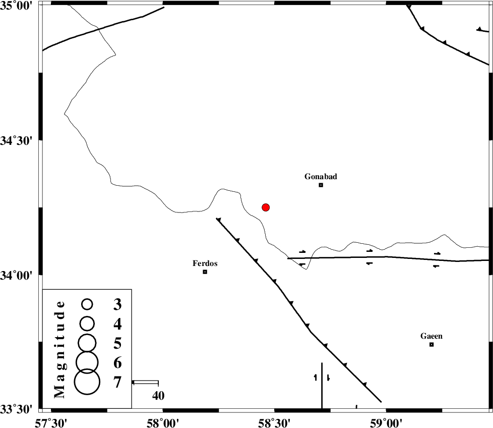
| Location | Lat:34.25 Lon: 58.46 |
| Region | Khorasan(center) Province, 24 km West of Gonabad |
Nearest Cities |
|
| 7 km of Zibod, Khorasan(center) Province | |
| 19 km North West of Kakhak, Khorasan(center) Province | |
| 23 km North East of Baghestan-e olia, Khorasan(center) Province | |
| 24 km North West of Marghash, Khorasan(center) Province | |
| 24 km North East of Brun, Khorasan(center) Province | |
| Depth | 29 km |
| Agency | |
Faults within 150 km: |
|
| FERDOWS_F (Length: 101 km) , Distance to epicenter: 21 km | |
| DASHT_E_BAYAZ_F (Length: 177 km) , Distance to epicenter: 23 km | |
| DUSTABAD_F (Length: 22 km) , Distance to epicenter: 68 km | |
| Number of Phases | 5 |
| RMS | 0.1 |
| Number of Stations | 3 |
| Error in Latitude | >5.4 km |
| Error in Longitude | 1.2 km |
| Error in Depth | 2.9 km |
Download waveform in seisan format
to download seisan software Click here
to access information about IIEES stations Click here
Amplitude | ||||||||
| UID | Agency | Station | Component | Amplitude | Period | Arrival Time | Proccessing Time | Signal Clip |
| 90876 | IIEES | TABS | N | 30.8 | 0.24 | 2013-10-28 16:11:14 | 2013-10-28 04:58:00 | n |
| 90877 | IIEES | SHRT | N | 19.9 | 0.38 | 2013-10-28 16:11:27 | 2013-10-28 04:58:00 | n |
Phase | ||||||||||||
| Agency | Station | Component | Phase Type | Phase Quality | First Motion | Observed Arrival Time | Time Residual | Loc. Flag | Input Weight | Distance | Azimuth | |
| IIEES | TABS | Z | Pg | E | 2013-10-28 16:10:55 | -0.07 | y | 141 | 242 | |||
| IIEES | TABS | N | Sg | E | 2013-10-28 16:11:12 | 0.06 | y | 141 | 242 | |||
| IIEES | SHRT | Z | Pn | E | 2013-10-28 16:11:00 | 0.05 | y | 182 | 111 | |||
| IIEES | SHRT | E | Sg | E | 2013-10-28 16:11:22 | 0 | y | 182 | 111 | |||
| IIEES | BSRN | Z | Pn | E | 2013-10-28 16:11:10 | -0.04 | y | 261 | 166 | |||