
Magnitude |
3.5 |
| Date & Time (UTC) | 2014-02-02 16:00:45.2 |
| Date & Time (Local) | 1392/11/13 19:30:45.2 |
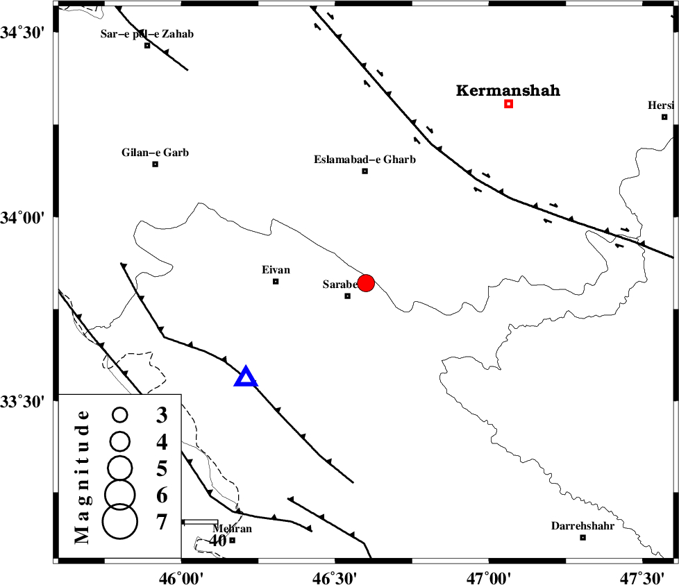
| Location | Lat:33.82 Lon: 46.6 |
| Region | Ilam Province, 7 km Sar Ableh |
Nearest Cities |
|
| 6 km of Mohammadqoli, Ilam Province | |
| 7 km North of Sar Ableh, Ilam Province | |
| 19 km West of Darbid-e mansuri, Kermanshah Province | |
| 21 km South West of Hamil, Kermanshah Province | |
| 22 km North of Sartang-e malehmaran, Ilam Province | |
| Depth | 14 km |
| Agency | |
Faults within 150 km: |
|
| HZF4 (Length: 492 km) , Distance to epicenter: 46 km | |
| MFF7 (Length: 99 km) , Distance to epicenter: 46 km | |
| MFF6 (Length: 144 km) , Distance to epicenter: 69 km | |
| Number of Phases | 8 |
| RMS | 0.1 |
| Number of Stations | 6 |
| Error in Latitude | >2.2 km |
| Error in Longitude | 2.6 km |
| Error in Depth | 3.9 km |
Download waveform in seisan format
to download seisan software Click here
to access information about IIEES stations Click here
Amplitude | ||||||||
| UID | Agency | Station | Component | Amplitude | Period | Arrival Time | Proccessing Time | Signal Clip |
| 91701 | IIEES | SHGR | E | 228.1 | 0.48 | 2014-02-02 16:02:08 | 2014-02-02 04:48:00 | n |
| 91702 | IIEES | SHGR | N | 240.7 | 0.64 | 2014-02-02 16:02:21 | 2014-02-02 04:48:00 | n |
Phase | ||||||||||||
| Agency | Station | Component | Phase Type | Phase Quality | First Motion | Observed Arrival Time | Time Residual | Loc. Flag | Input Weight | Distance | Azimuth | |
| IIEES | SNGE | Z | Pg | E | 2014-02-02 16:01:11 | -0.08 | y | 157 | 26 | |||
| IIEES | SHGR | Z | Pn | E | 2014-02-02 16:01:27 | -0.06 | y | 280 | 132 | |||
| IIEES | KHMZ | Z | Pn | E | 2014-02-02 16:01:31 | 0.05 | y | 312 | 91 | |||
| IIEES | KHMZ | N | Sg | E | 2014-02-02 16:02:12 | 0.04 | y | 312 | 91 | |||
| IIEES | ASAO | Z | Pn | E | 2014-02-02 16:01:33 | 0 | y | 326 | 75 | |||
| IIEES | ASAO | N | Sg | E | 2014-02-02 16:02:16 | -0.01 | y | 326 | 75 | |||
| IIEES | ZNJK | Z | Pn | E | 2014-02-02 16:01:38 | 0.12 | y | 369 | 30 | |||
| IIEES | GHVR | Z | Pn | E | 2014-02-02 16:01:46 | -0.05 | y | 435 | 79 | |||